All 50 questions from the National Business and Technical Examinations Board (NABTEB) Geography 2024 Objective paper, with the correct answer and a full explanation for each. Free, no signup needed.
As can be seen on the map, the contour interval is 50 metres. Note: Contour interval is the vertical distance between two consecutive contour lines on a topographic map. It represents the change in elevation between the two lines.
The highest point on the mapped area is approximately
A. 325 metresCorrect
B. 375 metres
C. 390 metres
D. 395 metres
Explanation
If the highest contour line (150m) is added to the additional elevation (which suggests another interval of 50m or more, given in option A), 325m is the closest option.
Which part of the mapped area can coastal fish be practised?
A. SouthCorrect
B. South western
C. North eastern
D. North western
Explanation
A coast is the land along the edge of a sea, ocean or other large body of water. It includes the shoreline, beaches, cliffs and other features where the land meets the water. It is an important zone for human activities such as fishing, shipping, tourism and recreation.
The feature marked Q on the mapped area be described as
A. meander
B. levee
C. elbow of capture
D. ox-bow lakeCorrect
Explanation
The feature marked Q is an ox-bow lake. An ox-bow lake is a U-shaped lake or pool that forms when a wide meander of a river is cut off, creating a free-standing body of water.
Which of the following settlements is likely to engage in fish processing?
A. Lola
B. SasaCorrect
C. Kako
D. Opom
Explanation
Note that even though Kako is close to the sea, it is not connected to any main road. Lack of good transportation link makes it less likely for fish processing.
Which of the following represents the correct sequence in which denudation occurs?
A. Weathering, erosion and depositionCorrect
B. Erosion, weathering and deposition
C. Weathering, deposition and erosion
D. Deposition, erosion and weathering
Explanation
The correct sequence is: Weathering → erosion → deposition. Weathering: Rocks break down into smaller pieces. Erosion: Weathered rock fragments are transported away. Deposition: Eroded sediment is deposited in a new location.
Which drainage pattern is best formed in areas of alternate hard and soft rocks?
A. TrellisedCorrect
B. Dendritic
C. Radial
D. Annular
Explanation
The drainage pattern best formed in areas of alternate hard and soft rocks is the trellis drainage pattern. This pattern resembles a garden trellis and is characterized by parallel main streams with short tributaries meeting them at right angles. The main streams usually flow along the softer rocks, while the tributaries cut through the harder rocks.
An intrusion of thick acid lava which forces overlying sedimentary rock layers to bulge into a dome may cool and solidify to form a
A. batholith
B. laccolithCorrect
C. dyke
D. lopolith
Explanation
A laccolith is a geological formation that occurs when magma intrudes between layers of sedimentary rock and causes the overlying layers to arch upward.
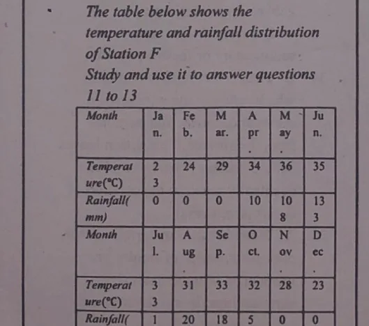
The Greek system of classifying climate is based on rainfall and temperature. It categorizes climates primarily according to the average monthly temperature and the distribution of precipitation throughout the year.
What will be the time at Greenwich meridian when it is 12 noon at longitude 60°E?
A. 4.00 a.m
B. 4.00 p.m
C. 8.00 a.mCorrect
D. 8.00 p.m
Explanation
Each degree of longitude corresponds to 4mins time difference (since 360° equals 24hrs). Thus, time difference between 0° and 60°E = (60×4)mins=240mins=4hrs. Since 0° is west of 60°E, we subtract 4hrs to get the time at 0° (Greenwich). Greenwich meridian = 12 noon − 4hrs = 8am.
A horst is a geological term that refers to a block of the earth's crust that has been uplifted relative to the surrounding areas, often due to tectonic forces. This uplift can occur along faults, resulting in the formation of block mountains.
Which of the following pair of landforms are surface features of a karst region?
A. I and II onlyCorrect
B. I and III only
C. II and III only
D. III and IV only
Explanation
Clints are the flat, elevated blocks of limestone and Grikes are the deep, narrow fissures or cracks that separate them. Both are characteristic surface features of a karst landscape.
Two towns, A and B are on the International Dateline, what would be the distance between the two towns if town A is located on latitude 40°N and town B is located on latitude 10°N?
A. 8880 kilometres
B. 5550 kilometres
C. 3330 kilometresCorrect
D. 2220 kilometres
Explanation
Difference in latitude = 40°−10°=30°. 1°=111km. Then, 30°=(111×30)km=3330km.
Which of the following best explains the breaking down of well jointed rocks into large rectangular shaped features by mechanical weathering?
A. Block disintegrationCorrect
B. Exfoliation dome
C. Landslide
D. Solifluction
Explanation
Block disintegration occurs when well-jointed rocks, particularly those with distinct and orthogonal joint patterns are weathered and eroded along these joints.
Which of the following conditions can produce a waterfall?
A. A sharp break in the bed of a riverCorrect
B. Elbow of capture of young river
C. Backward erosion
D. Lateral erosion
Explanation
A sharp break in the bed of a river can produce a waterfall. This typically occurs where a river flows over a resistant layer of rock followed by a softer layer below.
In which of the following regions will weathering by frost action occur throughout the year?
A. Cool temperateCorrect
B. Equatorial
C. Monsoon
D. Mediterranean
Explanation
In cool temperate regions, especially those with significant temperature fluctuations, frost action can occur year-round due to the presence of freezing temperatures during winter months.
The normal lapse rate refers to the average rate at which
A. radiant energy is converted to heat
B. air pressure decreases with altitude
C. air pressure increases with altitude
D. temperature decreases with altitudeCorrect
Explanation
The normal lapse rate refers to the average rate at which atmospheric temperature decreases with increasing altitude. It is typically around 6.5°C per kilometer.
Which of the following is a proof of the earth's spherical shape?
A. Circum navigationCorrect
B. Variations in the length of day and night
C. Marking of a year and fall of tides
D. Rise and fall of tides
Explanation
A proof of the sphericity of the earth is circumnavigation. It refers to the ability to travel around the earth in all directions and return to the starting point.
Which of the following types of rocks contain fossils?
A. Igneous
B. SedimentaryCorrect
C. Metamorphic
D. Volcanic
Explanation
Fossils are typically found in sedimentary rocks. This is because sedimentary rocks form from the accumulation and lithification of sediments which often contain the remains of plants and animals.
Lines drawn on maps connecting places with equal duration of sunshine are called
A. isohelsCorrect
B. isotherms
C. isonephs
D. isohyets
Explanation
The lines drawn on maps connecting places with equal duration of sunshine is called isohels. (Lines on a map connecting points of equal temperature are called isotherms.)
Which of the following occurs when the sun is vertically overhead at the equator?
A. EquinoxCorrect
B. Solstice
C. Deflection of winds and ocean currents
D. Rise and fall of tides
Explanation
The phenomenon where the sun is vertically overhead at the equator corresponds to equinoxes (both spring and autumn). On the equinoxes, there are nearly equal lengths of day and night worldwide.
Which of the following pair of ways can be used to solve the world's high population concentration problems? I. Family planning II. Sex education III. Early marriage IV. Industrialization
A. I and II onlyCorrect
B. I and III only
C. II and III only
D. III and IV only
Explanation
Family planning and sex education are useful ways of solving the world's high population concentration problems.
Which of the following countries in West Africa is well known for the production of diamonds?
A. Togo
B. Burkina Faso
C. Sierra LeoneCorrect
D. Benin
Explanation
Sierra Leone is well known for the production of diamonds. Diamond mining is a significant industry in Sierra Leone, contributing to its economy and global diamond markets.
Which of the following is a leading industrial area in North America?
A. The North Eastern industrial area of USACorrect
B. Central Canada industrial area
C. South Mexico industrial area
D. The Guatemala industrial area
Explanation
The leading industrial area in North America is the north eastern industrial area of USA. This region includes major cities like New York city, Boston, Philadelphia and Washington D.C
It is an intensive cultivation of fruits, vegetables or flowers, it is a small scale farming, the yields are very high per hectare, produce sold to customers are usually fresh and commonly practised in urban communities. The above statements are characteristics of
A. mixed farming
B. sericulture
C. market gardeningCorrect
D. viniculture
Explanation
Market gardening refers to the commercial production of fruits, vegetables, flowers and other plants on a relatively small scale typically for sale in local markets, grocery stores, restaurants or directly to consumers.
A large population can provide an abundant labour force, which can be advantageous for economic growth, development of industries and meeting labour demands across various sectors.
Which of the following best describes the relationship between rural and urban areas?
A. Urban areas are not as important as rural areas
B. Urban areas and rural areas depend on each otherCorrect
C. Rural areas exist only to serve urban areas
D. Urban areas can exist without rural areas
Explanation
Urban areas and rural areas depend on each other. Urban areas rely on rural areas for food, agricultural products, raw materials for industries etc. Rural areas rely on urban areas for market for their products, employment opportunities, infrastructure etc.
Which of the following activities can initiate deforestation? I. Lumbering II. Afforestation III. Excavation IV. Grazing
A. I and II only
B. I, III and IV onlyCorrect
C. II and III only
D. I, II, III and IV
Explanation
Lumbering and grazing can initiate deforestation. Lumbering involves cutting down trees for timber, leading to significant forest loss. Also, overgrazing by livestock damages vegetation and contributes to deforestation.
A. settlement pattern where buildings are scattered randomly
B. settlement pattern where buildings and homes are arranged in a line, often along a geographic feature such as a road, river or railwayCorrect
C. settlement pattern found only in urban areas
D. settlement pattern where buildings form a circle
Explanation
A linear settlement is a type of settlement pattern where buildings and homes are arranged in a line, often along a geographic feature such as a road, river or railway.
Advertisement
Sign up free to unlock
Score tracking
Practice history
Saved questions
Progress dashboard
Personalized sessions
Weak-topic breakdown
…and/or go further with premium services and No Ads.