Free account: track your progress — Sign up free

NECO Geography 2024 Theory Past Questions

All 8 questions from the National Examinations Council (NECO) Geography 2024 Theory paper, with the correct answer and a full explanation for each. Free, no signup needed.

Advertisement

Geography 2024 Theory — Question 1

1. Study the maps extract provided on a scale 1:50,000 and answer the questions that follow. (a) In your answer booklet, draw an outline of the mapped area to a third of its original size and state the scale of the new outline (6 marks) (b) In your new outline, insert and name: (i) River Nyamsu and its direction of flow with an arrow; (3 marks) (ii) the ridge at the south eastern part of the mapped area (2 marks) (iii) Iimisokakruba settlement (2 marks) (c) Describe three ways in which transportation network is influenced by the relief in the mapped area (6 marks) (d) Describe three ways in which transportation network is influenced by the relief in the mapped area (6 marks)
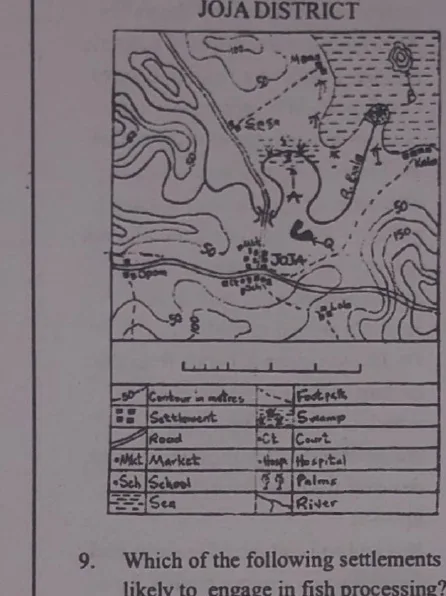
Diagram for question 1

Model answer

It is impractical to include the actual WAEC topographical map in this workbook due to its large size, which far exceeds the dimensions of a spreadsheet cell. Given this limitation, a full numerical solution cannot be presented without the source map; however, the method for each part is outlined below. (a) To reduce a map extract to a third of its original size: new scale = original scale × 3. Since the original scale is 1:50,000, the new scale becomes 1:150,000. Draw the outline with all linear dimensions reduced to one-third of the original (i.e., multiply each measured length on the original outline by 1/3), and label the new scale as 1:150,000 (or as a linear/statement scale showing the reduction). (b) (i) Locate River Nyamsu on the original map, trace its course onto the reduced outline at the correct relative position, and mark its direction of flow (from higher to lower relief / towards the sea or main river) with an arrow. (ii) Identify the ridge (a line of high ground, shown by close, roughly parallel contour lines) at the south-eastern part of the map and shade/mark it on the reduced outline, labelling it 'ridge'. (iii) Locate the settlement 'Iimisokakruba' at its correct relative position on the reduced outline and label it clearly. (c) & (d) Three ways in which the transportation network is influenced by relief in the mapped area: i. Roads and railways tend to follow valleys and gentler slopes, avoiding steep gradients which are difficult and costly to construct on. ii. Areas of rugged/hilly relief have a sparse or winding road network, while flatter lowland areas have a denser, more direct network of roads. iii. Rivers and steep-sided valleys act as barriers to transportation, so roads are often diverted, or bridges are constructed at the most convenient (usually narrowest or flattest) crossing points. iv. Settlements and roads tend to be concentrated along valley floors and lowlands where construction is easier and where farming/economic activities are concentrated, while higher relief areas remain less connected. v. Steep slopes may require roads to zigzag (switchback) to reduce gradient, increasing the length and cost of the route compared to a straight path on flat land.
Geography 2024 Theory — Question 2

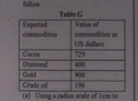
2. The table G below shows the value of commodities exported by a country in the year 2020. Study and use it to answer the questions that follow. (a) Using a radius scale of 1cm to represent 10 units, draw proportional circles to represent the value of exported commodities by the country in the year 2020 (13 marks) (b) Calculate the percentage of the value of gold exported in the year 2020 (2 marks)

Diagram for question 2

Model answer

(a) Using the radius scale of 1cm to 10 units, the radius of each proportional circle is found by taking the square root of each commodity's value (since the values are not too large) and then scaling down by the given ratio: Cocoa: √729 = 27 → radius = 27/10 = 2.7cm Diamond: √400 = 20 → radius = 20/10 = 2.0cm Gold: √900 = 30 → radius = 30/10 = 3.0cm Crude oil: √196 = 14 → radius = 14/10 = 1.4cm Draw four circles with these radii (2.7cm, 2.0cm, 3.0cm and 1.4cm), each labelled with its commodity name, and state 'radius scale: 1cm represents 10 units' beneath the diagram. (b) Total value of exported commodities = Cocoa($729) + Diamond($400) + Gold($900) + Crude oil($196) = $2,225. Percentage value of gold exported = (900/2225) × 100% = 40.449% ≈ 40.45%.

Geography 2024 Theory — Question 3

3. (a) List three processes of wind erosion (3 marks) (c) With the aid of a diagram, describe the characteristics and mode of formation of a zeugen (12 marks)

Model answer

(a) Three processes of wind erosion: i. Deflation: The removal of loose particles, such as dust and sand, from the ground surface by wind. ii. Abrasion: The wearing away of rocks and soil by the grinding action of wind-borne particles like sand and gravel. iii. Attrition: The reduction of particle size through collisions between wind-borne particles, leading to the breakdown of larger particles into smaller ones. (c) A zeugen is a type of rock formation that forms through the process of differential erosion, where softer rock layers erode faster than harder layers above them. Mode of formation: - Initial structure: The formation starts with a horizontal or nearly horizontal stratified structure, where a harder, more resistant rock layer overlays a softer, less resistant layer. - Erosion process: Over time, the softer underlying layer erodes faster (mainly by wind abrasion), undercutting the harder layer above. - Undercutting and collapse: Continued erosion eventually causes portions of the harder layer to collapse, exposing more of the softer layer beneath. - Formation of zeugen: As this process continues, it creates elongated, ridge-like formations where the harder rock forms a protective cap (mushroom-shaped) over remnants of the softer rock below, forming a series of ridges and furrows called zeugen. Characteristics of zeugen: - They appear as a series of parallel ridges and furrows. - The height varies significantly depending on the thickness of the harder rock and the extent of erosion. - They are commonly found in arid and semi-arid environments where wind erosion is a dominant force. - They are usually oriented in the direction of prevailing winds or the flow of wind-borne material. [Diagram: A simple cross-section sketch would show a lower, narrower pedestal of softer rock supporting a wider, flatter cap of harder resistant rock, with the wind-facing side more undercut than the sheltered side, giving a mushroom-like profile.]

Geography 2024 Theory — Question 4

4. (a) What is an igneous rock? (2 marks) (b) State three characteristics of igneous rocks (3 marks) (c) Explain five economic importance of igneous rock (10 marks)

Model answer

(a) An igneous rock is a type of rock that forms from the cooling and solidification of magma. Igneous rocks can form beneath the earth's surface as intrusive (plutonic) rocks or on the surface as extrusive (volcanic) rocks. Common examples include granite (intrusive) and basalt (extrusive). (b) Three characteristics of igneous rocks: - They can have a range of textures (from coarse-grained to fine-grained/glassy, depending on cooling rate). - They can be hard (e.g. granite, basalt) or soft (e.g. pumice, obsidian). - They rarely contain fossils, since they form from molten material. (c) Economic importance of igneous rocks: i. Building materials: Igneous rocks like granite, basalt and andesite are used as building and construction materials (e.g. for walls, kerbs, road aggregate). ii. Source of valuable minerals: They are sources of valuable minerals such as gold, diamonds and other precious metals/gems associated with igneous activity. iii. Manufacturing: They are used in the production of cement, concrete, glass and ceramics. iv. Decorative and ornamental use: Igneous rocks like granite, marble-like polished basalt and obsidian are used for decorative purposes, such as countertops, sculptures and jewelry. v. Cosmetics and skincare: Igneous rocks like obsidian and pumice are used in cosmetics, such as exfoliating scrubs and skincare products. vi. Scientific research: They are used in scientific research to study the earth's geological history and volcanic activity. vii. Water filtration: Igneous rocks like zeolites are used for water filtration and purification. viii. Construction of highways: Igneous rocks like basalt and andesite are used in highway construction due to their strength and durability.

Geography 2024 Theory — Question 5

5. (a) State three conditions that favour the development of karst topography (3 marks) (b) Describe the characteristics and mode of formation of a sink hole (12 marks)

Model answer

(a) Three conditions that favour the development of karst topography: i. High rainfall: Abundant rainfall dissolves the rocks and creates underground drainage systems. ii. Warm temperatures: Warm temperatures enhance chemical reactions, increasing the rate of rock dissolution. iii. Presence of soluble rocks: Rocks like limestone, dolomite and gypsum are prone to dissolution by slightly acidic water. (Also acceptable: acidic water containing carbon dioxide, and topography with gentle to moderate slopes which allows water to flow slowly and have more time to erode the rock.) (b) A sinkhole is a depression or hole that forms in the ground when a layer of soil or rock is removed or collapses. Modes of formation: - Dissolution: Sinkholes often form in areas with soluble bedrock, such as limestone or gypsum. Groundwater gradually dissolves these rocks, creating underground voids and caverns. - Collapse: When the roof of an underground cavern becomes too thin to support the weight above it, it can suddenly collapse, forming a sinkhole. - Human activity: Construction, mining, groundwater withdrawal and other human activities can disturb the structural integrity of the ground, leading to sinkhole formation. Characteristics of sinkholes: - Shape and size: Sinkholes vary from small depressions to large, deep holes, in oval, circular or irregular shapes. - Depth: They range from a few feet to several hundred feet deep. - Edges: They can have steep and abrupt, or gently sloping edges. - Surface water: They may be filled with water to form ponds/lakes, or remain dry. - Subsoil exposure: They often expose bedrock and subsoil layers, revealing geological strata and sometimes underground water systems.

Geography 2024 Theory — Question 6

6. (a) Using Koppen's system of classification of climates, identify the types of climate that are represented by the letters listed below: (i) Af (ii) Am (iii) Aw (3 marks) (b) Outline six characteristics of the Af climate (12 marks)

Model answer

(a) (i) Af: Tropical rainforest climate. It is characterized by high temperatures and significant year-round precipitation. There is no dry season. (ii) Am: Tropical Monsoon Climate. It is similar to the tropical rainforest climate but with a distinct dry season. The dry season is short and most precipitation occurs during the monsoon season. (iii) Aw: Tropical Savanna Climate (or Tropical wet and dry climate). It is characterized by a pronounced dry season, typically in the winter. Temperatures remain high throughout the year but there is a clear division between a wet season and a dry season. (b) Six characteristics of the Af climate (Tropical Rainforest Climate): - High temperatures throughout the year (average above 18°C in every month). - High humidity. - Heavy rainfall, evenly distributed throughout the year with no distinct dry season. - High rainfall intensity, often as convectional thunderstorms in the afternoon. - High cloud cover for most of the year. - High biodiversity, supporting dense equatorial rainforest vegetation.

Geography 2024 Theory — Question 7

7. (a) List three features that can be found in the middle course of a river (3 marks) (b) Describe the characteristics and mode of formation of a pothole (12 marks)

Model answer

(a) Three features found in the middle course of a river: - Meanders: Curved sections of the river channel formed by erosion and deposition. - Flood plains: Flat areas adjacent to the river, subject to periodic flooding. - Levees: Natural or artificial ridges along the river, formed by sediment deposition. (Also acceptable: terraces, oxbow lakes, point bars, braiding.) (b) A pothole is a rounded, bowl-shaped hollow eroded into the rocky bed of a river. Mode of formation: - Erosion: Potholes form when a rock surface is subjected to repeated erosion by water, which wears away the rock surface and creates a depression. - Abrasion: Sediment and debris (pebbles and stones) carried by the water act as abrasives, scouring the rock surface and deepening the depression as they are swirled around by turbulent flow (eddying). - Plucking: As the water flows, it may dislodge and remove fragments of rock, further enlarging the pothole. Characteristics of potholes: - They typically have a rounded, bowl-like shape, reflecting the erosive/swirling action of water and trapped stones. - They can range from small, shallow depressions to large, deep holes. - The sides of potholes are often steep and smooth, reflecting the erosive action of water. - The floor of a pothole is typically smooth and polished, reflecting the abrasive action of sediment and debris.

Geography 2024 Theory — Question 8

8. (a) Define atmospheric resources (3 marks) (b) Outline three importance of atmospheric resources (6 marks) (c) Highlight three human activities that adversely affect the composition of atmosphere (6 marks)

Model answer

(a) Atmospheric resources are elements and conditions in the earth's atmosphere that can be utilized for various human activities and natural processes. These resources include oxygen, carbon dioxide, water vapour, solar radiation and wind. (b) Three importance of atmospheric resources: i. Supports life: Atmospheric resources provide essential elements like oxygen, water and temperature regulation to sustain life on earth. ii. Agriculture and food production: Atmospheric resources like carbon dioxide, nitrogen and weather patterns are crucial for plant growth and crop production. iii. Energy and transportation: Atmospheric resources like wind and air currents enable renewable energy generation (e.g. wind power) and facilitate air transportation. (c) Three human activities that adversely affect the composition of the atmosphere: i. Burning of fossil fuels: This releases carbon dioxide, sulphur dioxide and other pollutants that alter the atmosphere's natural composition. ii. Deforestation: This reduces the number of trees available to absorb carbon dioxide, increasing greenhouse gas concentration. iii. Industrial processes: Manufacturing and industrial activities release various pollutants, including particulate matter and toxic gases, into the atmosphere. (Also acceptable: agricultural activities producing methane, transportation emissions, fossil fuel extraction and refining, waste management/burning.)

Advertisement

Sign up free to unlock

  • Score tracking
  • Practice history
  • Saved questions
  • Progress dashboard
  • Personalized sessions
  • Weak-topic breakdown

…and/or go further with premium services and No Ads.