All 50 questions from the West African Examinations Council (WAEC) Geography 2022 Objective paper, with the correct answer and a full explanation for each. Free, no signup needed.
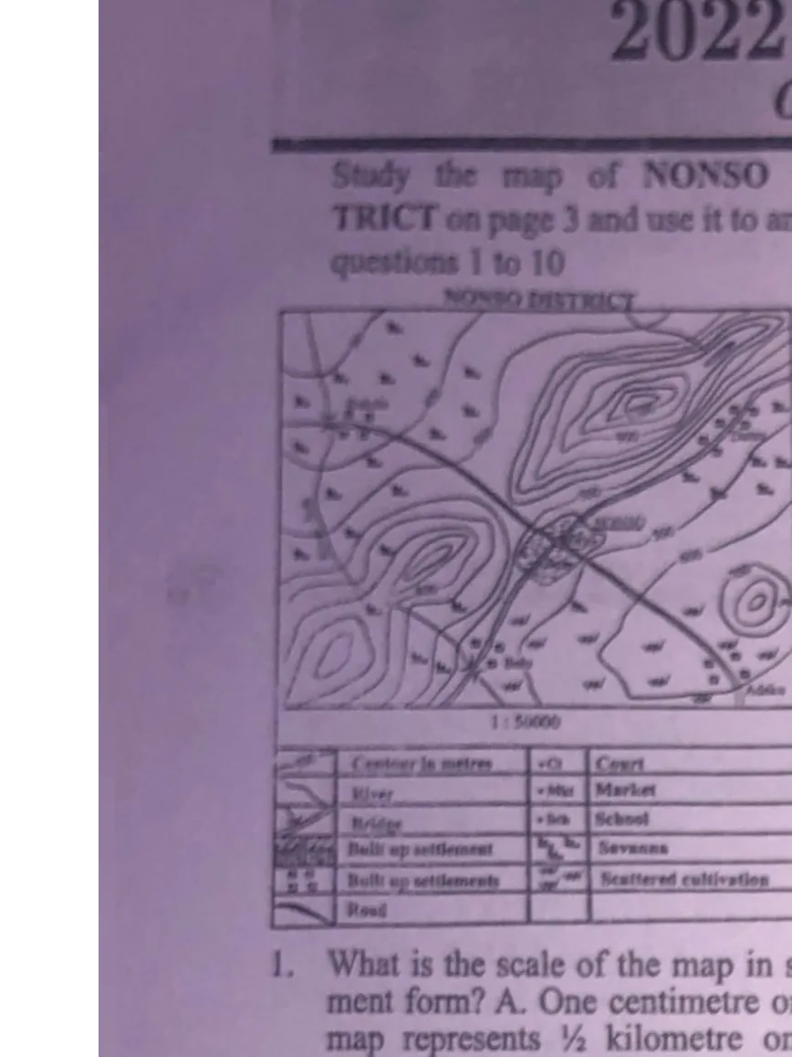
If the map is reduced by half its original size, what would be the scale of the new map?
A. 1:25,000
B. 1:50,000
C. 1:100,000Correct
D. 1:150,000
Explanation
When a map is reduced by a factor, the denominator of the scale increases by that same factor. Reducing the map to half its size changes the scale from 1:50,000 to 1:100,000.
Two towns, P and Q, are on the International Date Line and in the same hemisphere. If the distance between the two towns is 444 km and town P is located on latitude 3°N, on what latitude is town Q located?
A. 10°N
B. 7°NCorrect
C. 4°N
D. 1°N
Explanation
A difference in latitude of 1° corresponds to about 111km. 444km ÷ 111km = 4° difference in latitude. Since P is at 3°N, Q is at 3°N+4° = 7°N.
A. There is a distance of 111km for every 1° of latitudinal differenceCorrect
B. A time difference of 4 minutes exists for every 15° of longitude
C. Any two opposite lines of latitude make a Great Circle
D. The Sun is overhead at noon at the Tropic of Cancer on December 22
Explanation
There is a distance of 111km for every 1° of latitude. (Any two opposite lines of longitude — not latitude — make a Great Circle; a time difference of 1 hour, not 4 minutes, exists for every 15° of longitude; and the sun is overhead at the Tropic of Cancer on June 21, not December 22.)
In its old stage, a river would: I. be interrupted by waterfalls and rapids II. flow sluggishly and develop pronounced meanders III. flow fast and have truncated spurs IV. develop levees and have a flood plain
A. II and IV onlyCorrect
B. II and III only
C. I and II only
D. I and III only
Explanation
In its old (lower course) stage, a river flows slowly through a broad, flat floodplain, developing pronounced meanders (II) due to the slow speed and high deposition, and depositing along its banks to form levees and a flood plain (IV).
The type of cloud from which thunderstorms and heavy rain are experienced in the Tropics is
A. altostratus
B. cirrus
C. cumulus
D. cumulo-nimbusCorrect
Explanation
The cumulonimbus cloud is associated with thunderstorms and extreme weather, including heavy torrential rain, hailstorms, lightning and even tornadoes.
Which type of mountain is also called the mountain of denudation?
A. Block mountain
B. Volcanic mountain
C. Residual mountainCorrect
D. Fold mountain
Explanation
Residual mountains are also called mountains of denudation because they are formed by denudation agents (ice, running water, wind, etc.) acting on already existing mountains.
The weathering process which is commonly found in limestone regions is
A. hydrolysis
B. exfoliation
C. Oxidation
D. solutionCorrect
Explanation
Carbonation, a type of solution weathering, is common in limestone regions: atmospheric carbon dioxide dissolves in water and reacts with rocks (like limestone) that contain calcium carbonate.
It is composed of layers of ash and cinders alternating with lava. It has a broad base and steep convex slopes. The above features are associated with
A. batholith
B. laccolith
C. shield volcano
D. composite coneCorrect
Explanation
Composite cones (stratovolcanoes) are made up of alternating layers of lava, volcanic ash and fragmented rocks, giving them a broad base and steep convex slopes.
Which of the following pairs are characteristics of igneous rocks? They: I. are stratified II. are metamorphosed rocks III. are crystalline IV. originate from molten magma
A. I and II only
B. II and III only
C. II and IV only
D. III and IV onlyCorrect
Explanation
Igneous rocks are formed from the cooling and solidification of magma (IV) and are granular/crystalline in nature (III); they contain no fossils and have no actual strata (ruling out I and II).
Which of the following climatic features describes the Equatorial climate?
A. Double maximum rainfall regimeCorrect
B. Winter rain, summer drought
C. Hot and dry throughout the year
D. Single maximum rainfall regime
Explanation
The Equatorial climate is characterized by a double maxima rainfall regime (two rainfall peaks in the year, corresponding to the sun's overhead passages).
The formation of block mountains is best associated with
A. accumulation of materials ejected from within the earth's crust
B. solidification of magma within the earth's crust
C. uplifting of a crustal block between two parallel faultsCorrect
D. vertical movement of sediments into geosynclines
Explanation
Block mountains are formed when faults/cracks in the earth's crust cause some blocks of rock to be uplifted relative to others between two parallel faults.
Which of the following landforms is not associated with an advancing shoreline?
A. Spit
B. StackCorrect
C. Beach
D. Tombolo
Explanation
A stack is formed by wave erosion (a retreating/eroding shoreline feature), unlike a spit, beach or tombolo, which are associated with deposition and an advancing shoreline.
The term relative location of settlement refers to
A. an imaginary point of the settlement
B. the nature of the buildings within the settlement
C. the position of buildings in relation to others
D. the position of settlements in relation to othersCorrect
Explanation
Relative location refers to the position of a settlement in relation to other settlements (as opposed to absolute location, which is a precise, defined point on earth).
Which of the following reasons accounts for the low traffic on rivers in Africa?
A. Presence of rapids and waterfallsCorrect
B. Only used for fishing
C. Wide valleys
D. Change of colour during rainy seasons
Explanation
Many African rivers contain numerous waterfalls, rapids and gorges, which make them less useful and more difficult for transportation, leading to low traffic.
The trade liberalization policy of ECOWAS is aimed at
A. fostering unity and peace among member states
B. taking a common stand on world issues
C. removing trade barriers among member statesCorrect
D. ensuring cultural cooperation
Explanation
The objective of ECOWAS's trade liberalization scheme is to remove trade barriers by abolishing customs duties on imports/exports and eliminating non-tariff barriers among member states, establishing a free trade area.
The transport system which is most affected by climatic factors is
A. water transport
B. rail transport
C. road transport
D. air transportCorrect
Explanation
Air transport is the transport system most affected by climatic factors, although other systems (e.g. water transport, affected by rainfall) can also be affected.
Transportation helps economic development through all the following except
A. diffusion of ideas and technology
B. promotion of national and international trade
C. movement of people and commodities
D. distribution of populationCorrect
Explanation
Transportation aids economic development by promoting the diffusion of ideas/technology, national and international trade, and the movement of people and commodities — not by directly distributing population.
Light industries are usually less capital-intensive than heavy industries and produce goods for end users; the textile industry is an example of a light industry.
Advertisement
Sign up free to unlock
Score tracking
Practice history
Saved questions
Progress dashboard
Personalized sessions
Weak-topic breakdown
…and/or go further with premium services and No Ads.