All 50 questions from the West African Examinations Council (WAEC) Geography 2024 Objective paper, with the correct answer and a full explanation for each. Free, no signup needed.
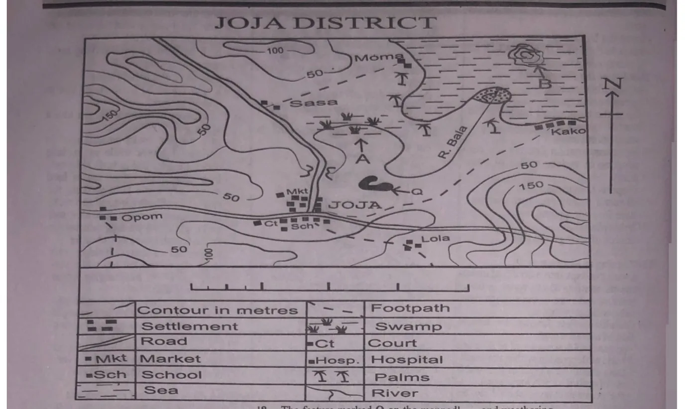
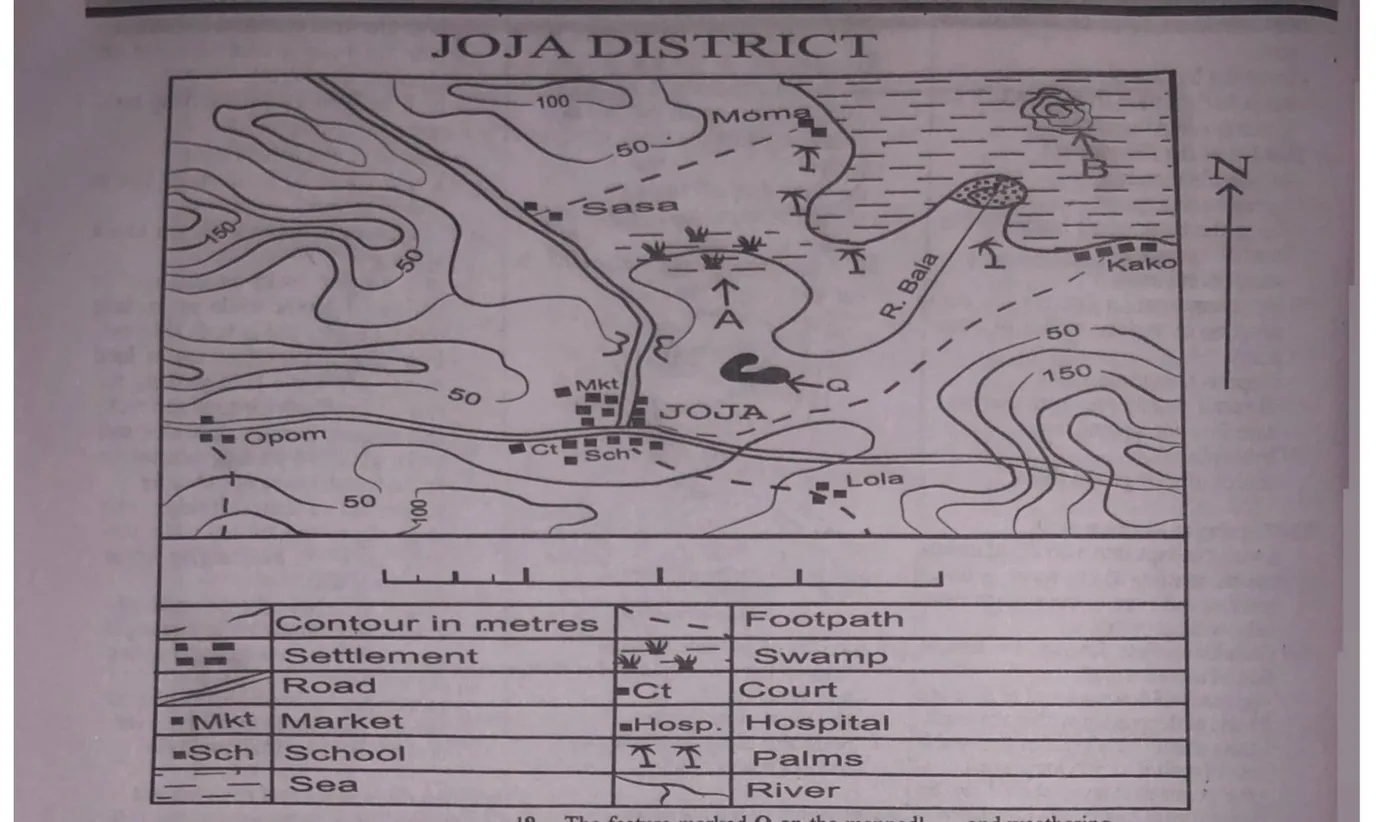
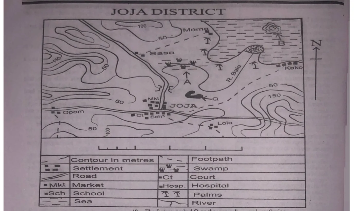
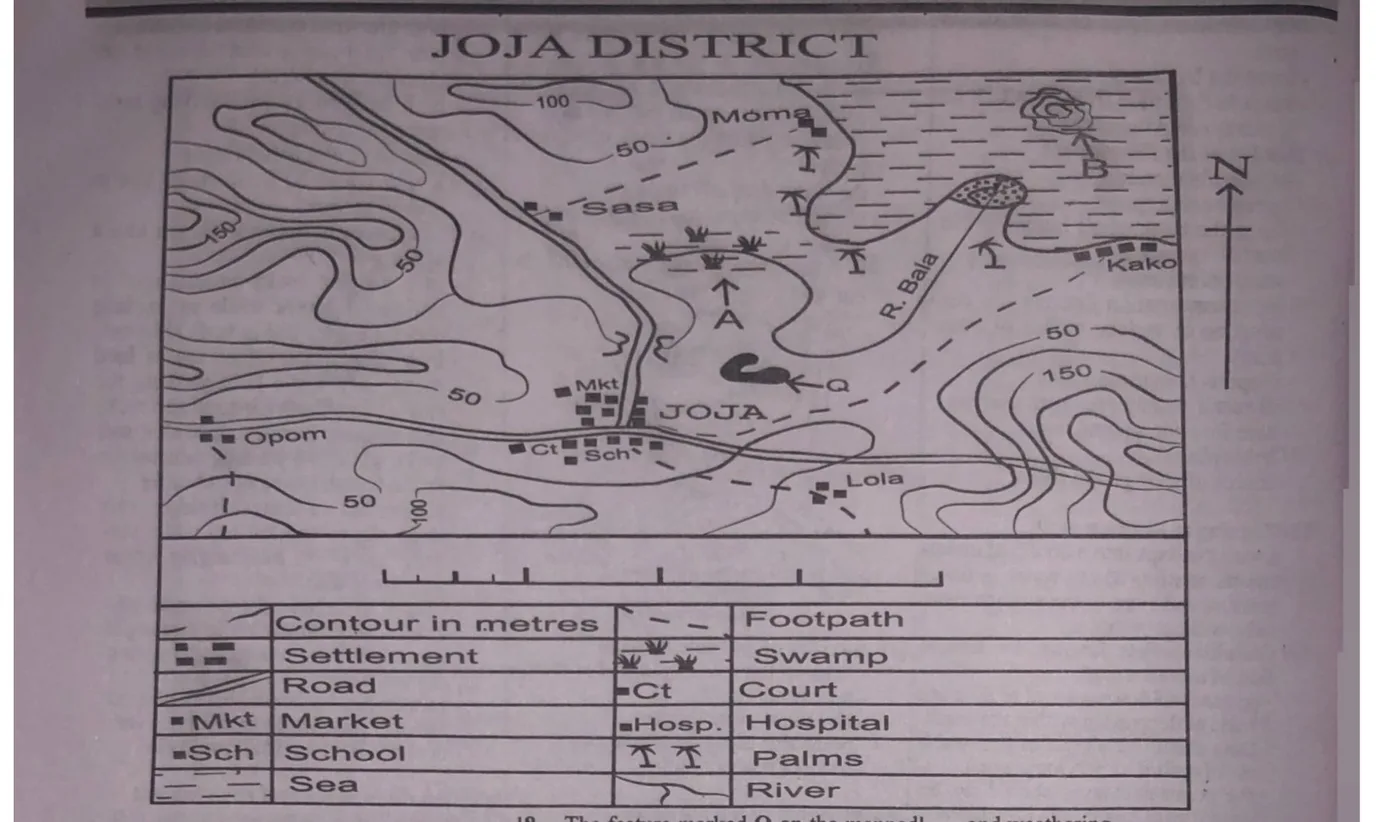
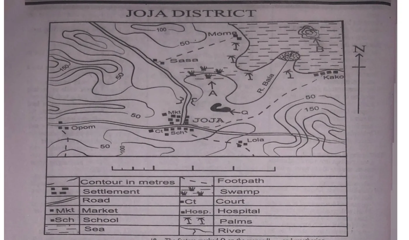
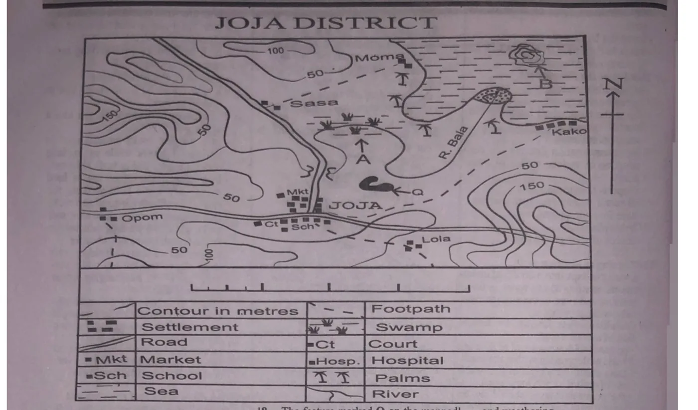
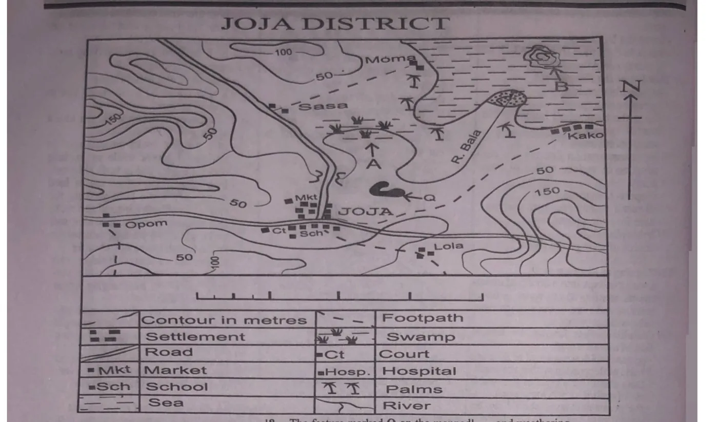
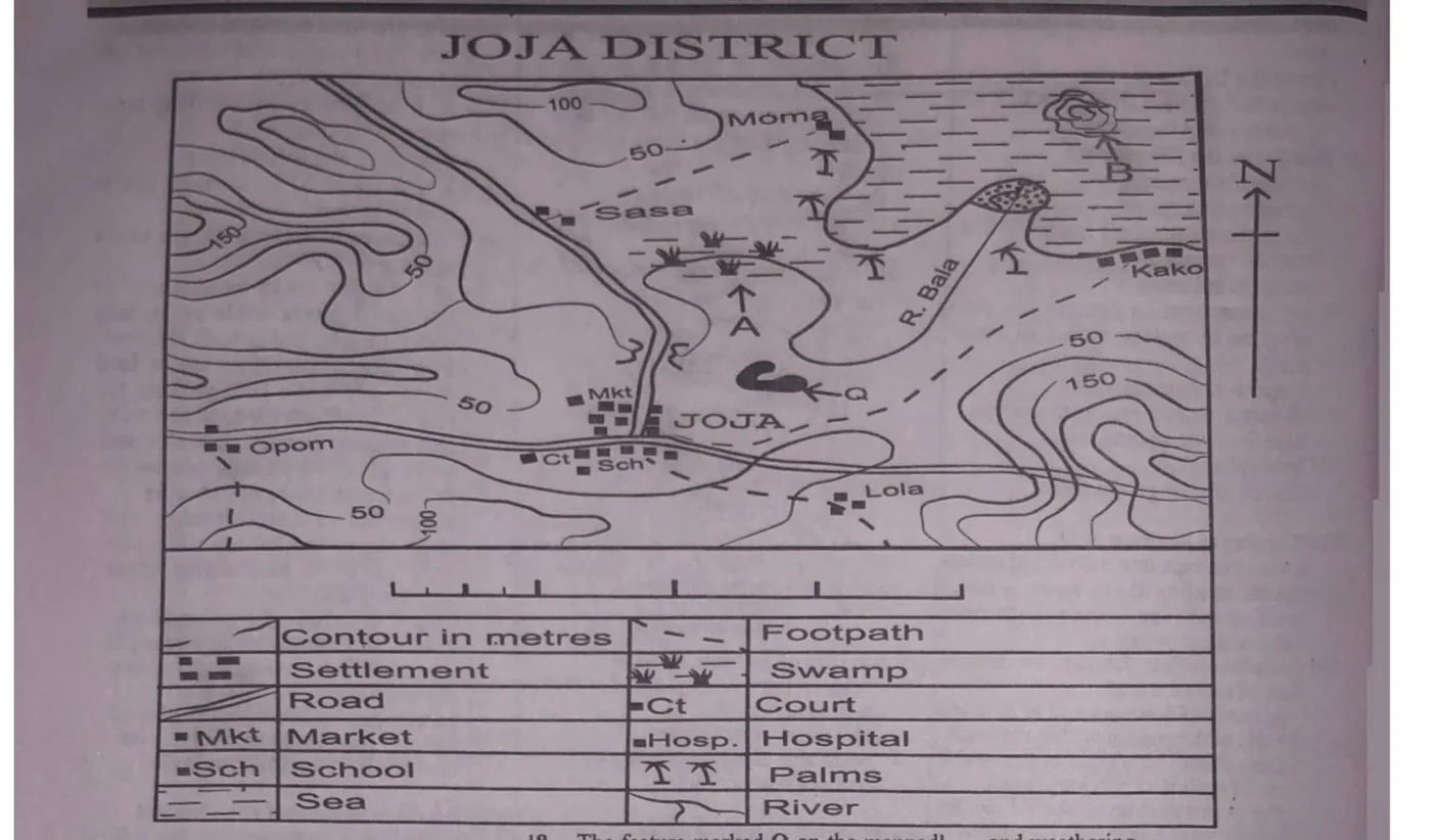
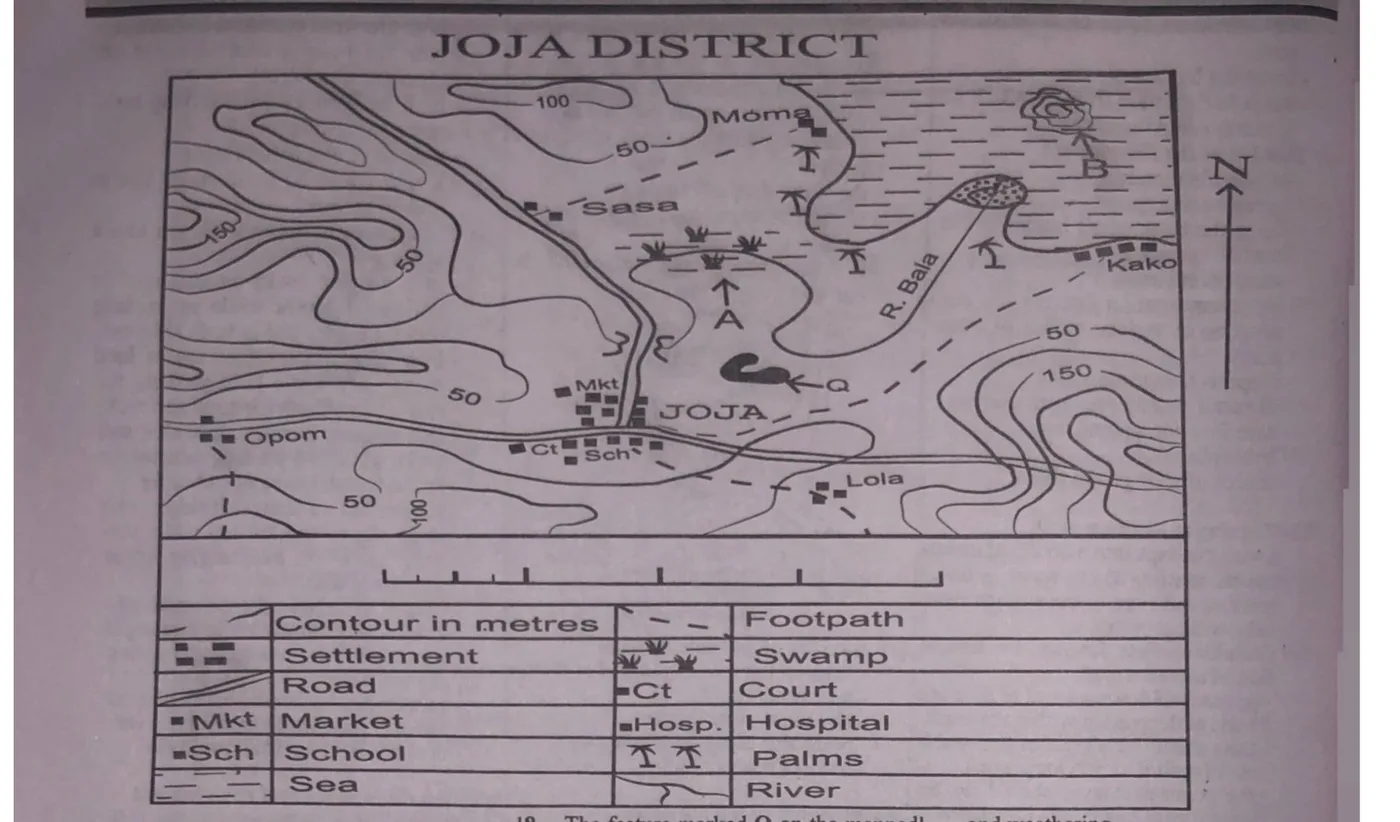
Study the map of JOJA DISTRICT (use it to answer questions 1 to 10). What is the scale of the map in statement form?
A. 1 centimetre on the map represents, 2 kilometres on the ground.
B. 1 centimetre on the map represents, 1 kilometre on the ground.
C. 1 centimetre on the map represents ½ kilometre on the ground.
D. 1 centimetre on the map represents, kilometre on the ground.
Explanation
The linear scale given on the map is incomplete. A complete linear scale has the distance represented by each segment indicated on it, so the WAEC key records no valid answer for this item.
The feature at the mouth of River Bala is likely to be a
A. waterfall.
B. river capture.
C. saddle.
D. delta.Correct
Explanation
A delta typically forms at the mouth of a river, where the river deposits sediment and splits into multiple distributaries, creating a network of channels, wetlands and sedimentary deposits.
The distance as the crow flies from Opom to Moma is approximately
A. 4 kilometres.
B. 6 kilometres.
C. 12 kilometres.
D. 16 kilometres.
Explanation
Since the scale of the map is incomplete/not fully known, the ground distance cannot be reliably calculated, so the WAEC key records no valid answer for this item.
Which of the following settlements is likely to engage in fish processing?
A. SasaCorrect
B. Kako
C. Lola
D. Opom
Explanation
Since Sasa is by the side of a road (which directly leads to the market) and very close to the sea, the settlement is likely to engage in fish processing.
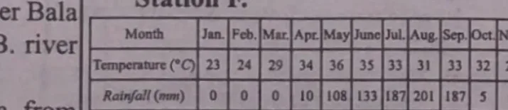
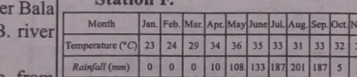
The table below shows the temperature and rainfall distribution of Station F. Study and use it to answer questions 11 to 13. The annual rainfall recorded at Station F is
A. 831 mm.Correct
B. 813 mm.
C. 381 mm.
D. 318 mm.
Explanation
Annual rainfall at Station F = (0+0+0+10+108+133+187+201+187+5+0+0)mm = 831mm.
Which of the following represents the correct sequence in which denudation occurs?
A. Weathering, erosion and depositionCorrect
B. Erosion, weathering and deposition
C. Weathering, deposition and erosion
D. Deposition, erosion and weathering
Explanation
The correct sequence of denudation is: Weathering (breakdown of rocks into fragments) - Erosion (transportation of the fragments away from the original location) - Deposition (settling of fragments in a new location).
Which drainage pattern is best formed in areas of alternate hard and soft rocks?
A. TrellisedCorrect
B. Dendritic
C. Radial
D. Annular
Explanation
A trellised drainage pattern is characterized by a network of streams and rivers that form a rectangular or grid-like pattern, typically found in areas with alternating layers of hard and soft rocks.
Rocks formed through cementation of accumulated materials under water is
A. metamorphic.
B. igneous.
C. sedimentary.Correct
D. acidic.
Explanation
Sedimentary rocks are formed from the accumulation and compression of sediments, such as mineral particles, organic matter and rock fragments. Examples are shale, sandstone and breccia.
An intrusion of thick acid lava which forces overlying sedimentary rock layers to bulge into a dome shape and solidify to form a
A. batholith.
B. laccolith.Correct
C. dyke.
D. lopolith.
Explanation
A laccolith is a type of igneous intrusion that forms when thick, acidic lava pushes up overlying sedimentary rock layers, causing them to bulge into a dome shape. As the lava cools and solidifies, it forms this distinctive body of rock.
What will be the time at Greenwich meridian when it is 12 noon at longitude 60°E?
A. 4.00 a.m
B. 4.00 p.m
C. 8.00 a.mCorrect
D. 8.00 p.m
Explanation
The longitude difference between Greenwich (0°) and 60°E is 60°. Since a 15° difference equals a 1-hour time difference, 60° equals a 4-hour difference. Travelling west from 60°E to reach 0°, we subtract time: 12 noon - 4 hrs = 8.00 a.m.
The movement of the earth around the sun on its elliptical orbit is called
A. rotation.
B. axis.
C. revolution.Correct
D. gravitation.
Explanation
The movement of the earth around the sun on its elliptical orbit is known as revolution, taking approximately 365¼ days to complete. Rotation is the earth's spin on its own axis, taking approximately 24 hours.
A horst is a geological structure that forms when a block of rock is uplifted along faults, creating a raised area or ridge; it is a characteristic feature of block mountains.
Two towns, A and B are on the International Dateline, what would be the distance between the two towns if town A is located on latitude 40°N and town B is located on latitude 10°N?
A. 8880 kilometres
B. 5550 kilometres
C. 3330 kilometresCorrect
D. 2220 kilometres
Explanation
A = 40°N, B = 10°N. Difference in latitude = (40-10)° = 30°. Since 1° = 111km, 30° = (111 x 30)km = 3330km.
Wind erosion results in the formation of all of the following landforms except
A. zeugen.
B. yardang.
C. ventifact.
D. barchan.
Explanation
Zeugen, yardang, ventifact and barchan can all be formed through processes related to wind action, so the WAEC key notes no exception among these options.
Which of the following best explains the breaking down of well jointed rocks into large rectangular shaped features by mechanical weathering?
A. Block disintegrationCorrect
B. Exfoliation dome
C. Landslide
D. Solifluction
Explanation
Block disintegration is a type of mechanical weathering that occurs when well-jointed rock (rocks with closely spaced fractures or joints) breaks down into large, rectangular-shaped blocks or features.
Which of the following sequence is correct in the formation of a stack?
A. Cave, arch, headland, stack
B. Headland cave, arch, stackCorrect
C. Headland, cave, stack, arch
D. Cave, headland, arch, stack
Explanation
The correct sequence is: Headland (the starting point) - Cave (forms through erosion) - Arch (forms as the cave is eroded further) - Stack (forms as the arch collapses).
In which of the following regions will weathering by frost action occur throughout the year?
A. Cool temperateCorrect
B. Equatorial
C. Monsoon
D. Mediterranean
Explanation
Frost weathering occurs when water seeps into cracks and joints in rock, freezes and expands, causing the rock to break apart. In cool temperate regions, frost action can occur throughout the year, especially at higher elevations or in areas with permafrost.
The normal lapse rate refers to the average rate at which
A. radiant energy is converted to heat
B. air pressure decreases with altitude
C. air pressure increases with altitude
D. temperature decreases with altitude.Correct
Explanation
The normal lapse rate refers to the average rate at which temperature decreases with an increase in elevation/altitude in the atmosphere. It is about 6.5°C per kilometre.
Which of the following is a proof of the earth's spherical shape?
A. CircumnavigationCorrect
B. Variations in the length of day and night
C. Marking of a year
D. Rise and fall of tides
Explanation
Circumnavigation is travelling around the world in a continuous path, returning to the starting point. It proves the earth's spherical shape because on a flat earth you would eventually reach an edge, but circumnavigation shows there is no edge.
Lines drawn on maps connecting places with equal duration of sunshine are called
A. isohels.Correct
B. isotherms.
C. isonephs.
D. isohyets.
Explanation
Isohels are lines on a map connecting points with equal duration of sunshine/solar radiation. Isotherms connect points of equal temperature, and isonephs connect points of equal precipitation/rainfall.
Which of the following examples of rock is most likely to be weathered by the process of solution?
A. Slate
B. Graphite
C. LimestoneCorrect
D. Granite
Explanation
Limestone is a sedimentary rock composed primarily of calcium carbonate, and is highly susceptible to weathering through solution (chemical weathering) when acidic rainwater dissolves the calcium carbonate, leading to karst processes.
Which of the following occurs when the sun is vertically overhead at the equator?
A. EquinoxCorrect
B. Solstice
C. Deflection of winds and ocean currents
D. Rise and fall of tides
Explanation
When the sun is vertically overhead at the equator, it marks the occurrence of an equinox, when day and night are approximately equal in length. This occurs twice a year, around March 21 and September 23.
Which of the following pair of ways can be used to solve the world's high population concentration problems? I. Family planning II. Sex education III. Early marriage IV. Industrialization
A. I and II onlyCorrect
B. II and III only
C. II and IV only
D. I and III only
Explanation
Sex education and family planning are useful ways of solving the world's high population concentration problems.
Which of the following countries in West Africa is well known for the production of diamonds?
A. Togo
B. Burkina Faso
C. Sierra LeoneCorrect
D. Benin
Explanation
Sierra Leone is well known for the production of diamonds. The country has a significant diamond mining industry and is known for its high-quality diamonds.
Which of the following is a leading industrial area in North America?
A. The North Eastern industrial area of USACorrect
B. Central Canada industrial area
C. South Mexico industrial area
D. The Guatemala industrial area
Explanation
The northeastern industrial area of the USA is a leading industrial area in North America, often referred to as the "Rust Belt", with a long history of heavy industry, manufacturing and economic development.
'It is an intensive cultivation of fruits, vegetables or flowers, it is small scale farming, the yields are very high per hectare, produce sold to customers are usually fresh and commonly practised in urban communities'. The above statements are characteristics of
A. mixed farming.
B. sericulture.
C. market gardening.Correct
D. viniculture.
Explanation
Market gardening is a type of small-scale farming where fruits, vegetables, flowers and other plants are grown for sale directly to consumers, typically through farmers' markets, local retailers or community-supported agriculture programs.
Which of the following best describes the relationship between rural and urban areas?
A. Urban areas are not as important as rural areas.
B. Urban and rural areas depend on each other.Correct
C. Rural areas exist only to serve urban areas.
D. Urban areas can exist without rural areas.
Explanation
There is interdependence between urban and rural areas. Rural areas supply food, labour and natural resources while urban areas provide markets, manufactured goods and services.
Which of the following pairs of activities can initiate deforestation? I. Lumbering II. Afforestation III. Excavation IV. Grazing
A. I and IV onlyCorrect
B. II and III only
C. II and I only
D. II only
Explanation
Both lumbering and grazing can initiate deforestation. Lumbering removes trees directly, while grazing, particularly when overdone, damages vegetation.
Wood carving, leatherwork and cloth weaving are examples of
A. chemical industry.
B. power industry.
C. heavy industry.
D. local craft industry.Correct
Explanation
The local craft industry involves the production of handmade goods by artisans within a community, typically including items like pottery, textiles, woodwork and other traditional crafts.
Population density is the number of people living per unit area, often expressed as individuals per square kilometre or square mile. It measures how crowded a region is.