All 51 questions from the West African Examinations Council (WAEC) Geography 2025 Objective paper, with the correct answer and a full explanation for each. Free, no signup needed.
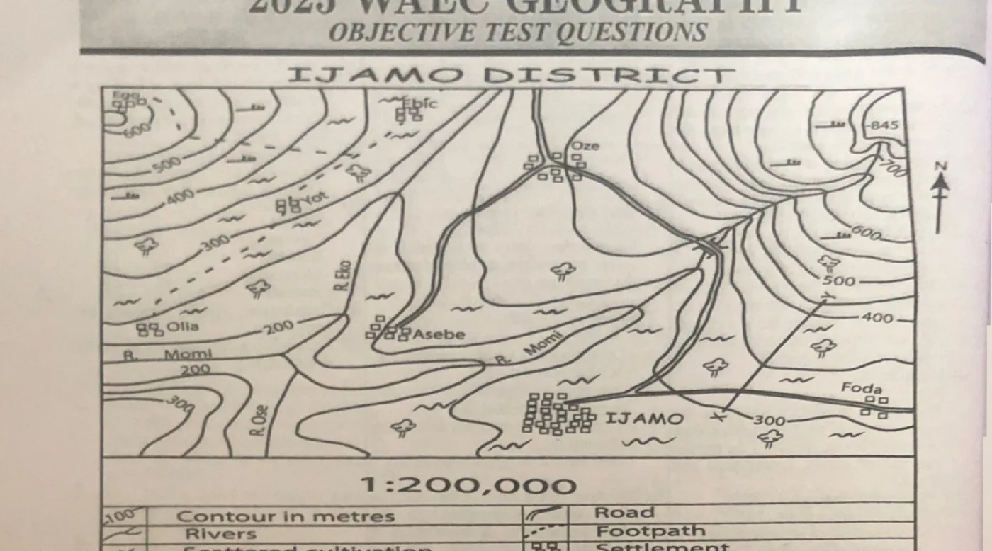
The scale of the map in statement form is
A. one centimeter on the map represents half kilometers on the groundB. one centimeter on the map represents one kilometre on the groundC. one centimeter on the map represents two kilometers on the groundCorrect D. one centimeter on the map represents three kilometers on the groundExplanation The map scale is 1:200,000, meaning 1 cm on the map represents 200,000 cm (2 km) on the ground.
What is the approximate bearing of Ebie from Oze?
A. 32°B. 58°C. 302°Correct D. 350°Explanation Ebie lies to the northwest of Oze. Drawing a line from Oze to Ebie and measuring with a protractor gives a bearing close to 302°.
What will be the new scale of the map in Representative Fraction if the map is enlarged to twice its original size?
A. 1:100,000Correct B. 1:200,000C. 1:300,000D. 1:400,000Explanation Enlarging a map to twice its size makes every distance represent a smaller area on the ground, so the Representative Fraction is halved: 1:200,000 becomes 1:100,000.
How many tributaries has River Momi?
Explanation River Momi is fed by two main tributaries, as shown on the map.
What is the likely occupation of the people of IJAMO settlement
A. fishingB. agricultureCorrect C. miningD. botanyExplanation The map shows scattered cultivation, forest, and grassland around the area, indicating farming activities.
The area of the map is approximately
A. 1101 km²B. 832 km²Correct C. 823 km²D. 332 km²Explanation Map scale is 1:200,000, so 1 cm² on the map represents 4.41 km² in reality. Map area ≈ 193.75 cm², giving a real area close to 775 km², nearest to 832 km².
The distance in kilometres as the crow flies from Ofia to Yot is approximately
A. 7 kilometersB. 10 kilometersCorrect C. 15 kilometersD. 17 kilometersExplanation The straight-line distance from Ofia to Yot on the map is about 5 cm. Since 1 cm = 2 km, the actual distance is about 10 km.
The second largest settlement on the mapped area is
A. IjamoB. OzeCorrect C. FadaD. AsebeExplanation Ijamo is the largest settlement on the map; Oze is the second-largest.
Ebie settlement is located in the
A. northern part of the mapped areaCorrect B. western part of the mapped areaC. southern part of the mapped areaD. eastern part of the mapped areaExplanation Ebie is located near the top edge of the mapped area, in the northern part.
The symbol •845 in the northeastern part of the mapped area is known as
A. hachureB. spot heightCorrect C. benchmarkD. valleyExplanation The symbol •845 marks a specific elevation point on the map, which is a spot height.
The table below shows the temperature and rainfall distribution of Station Q. What is the annual range of temperature for station Q
A. 14°CCorrect B. 21°CC. 27°CD. 35°CExplanation Annual range of temperature = Maximum temperature − Minimum temperature = 35°C − 21°C = 14°C.
How many months of dry season has the station?
Explanation A dry month is one with less than 60 mm of rainfall. From the table, January, February, November and December are dry, giving 4 months.
The annual rainfall recorded at Station Q is
A. 726 mmB. 871 mmCorrect C. 360 mmD. 148 mmExplanation Summing all monthly rainfall values from the table gives a total annual rainfall of 871 mm.
Which of the following types of rainfall occurs when air masses of different characteristics meet and their air mixes
A. convectional rainfallB. relief rainfallC. orographicD. frontal rainfallCorrect Explanation When warm and cold air masses of different characteristics meet, the warm air rises over the cold air, cools, and produces frontal rainfall.
Which coastal feature has the following characteristics? I. Produced by wave erosion II. enlarges through alternate compression and expansion of air III. connects the top of the cliff to the sea IV. has narrow, chimney like opening
A. blow holeCorrect B. tomboloC. beachD. spitExplanation This describes a blowhole, a coastal feature formed when seawater is forced through a narrow opening in a cliff, creating a spray.
The grass in the Savanna regions has adapted to the climate by
A. growing very short and in layersCorrect B. lying dormant during the long droughtC. having shallow roots which spread near the surfaceD. having evergreen leavesExplanation Savanna grasses adapt to seasonal droughts by growing short and in layers, allowing them to survive dry periods and conserve resources.
A line drawn on maps joining places of equal atmosphere pressure is called
A. isohalineB. isohyetC. isobarCorrect D. isonephExplanation An isobar is a line joining places of equal atmospheric pressure on a map.
On the 22nd of December, the sun is overhead at midday along the
A. Tropic of cancerB. Arctic circleC. Antarctic circleD. Tropic of CapricornCorrect Explanation On December 22nd, the Southern Hemisphere is tilted towards the Sun, so the Tropic of Capricorn (23.5°S) receives direct overhead sunlight at noon.
The temperature at the top of a mountain is 7°C. What will be the temperature at the foot of the mountain if it is 5000 meters above the sea level
A. 25.5°CB. 32.5°CC. 35.9°CD. 39.5°CCorrect Explanation Temperature decreases by about 6.5°C per 1000 m of elevation. For 5000 m, the drop is 32.5°C, so the temperature at the foot is 7°C + 32.5°C = 39.5°C.
On which of the following pairs of dates do solstices occur
A. 21st June and 22nd DecemberCorrect B. 21st March and 23rd DecemberC. 21st June and 23rd SeptemberD. 23rd September and 22nd DecemberExplanation Solstices occur when the Sun is furthest north or south of the equator: 21st June (over the Tropic of Cancer) and 22nd December (over the Tropic of Capricorn).
Which of the following is a process of chemical weathering
A. block disintegrationB. hydrolysisCorrect C. exfoliationD. salt wedgingExplanation Hydrolysis is a chemical reaction between minerals in rocks and water that weakens and breaks down the rock, making it a chemical weathering process.
Rift valleys are landforms associated with
A. foldingB. faultingCorrect C. vulcanicityD. residual mountainExplanation Rift valleys form when a section of the Earth's crust drops down between parallel faults due to tension, making faulting the associated process.
Which of the following pairs of landforms are produced by wind erosion in hot desert? I. Zeugen II. Seif III. Yardang IV. Barchan
A. I and IIB. I and IIICorrect C. II and IVD. III and IVExplanation Zeugen and Yardang (I and III) are both erosional features produced by wind erosion. Seif and Barchan are depositional features.
A lunar eclipse occurs when the
A. sun comes between the earth and the moonB. moon comes between the sun and the moonC. earth comes between the sun and the moonCorrect D. sun misses its orbitExplanation A lunar eclipse happens when the Earth comes between the Sun and the Moon, casting the Earth's shadow onto the Moon.
The most useful function of the ozone layer in the atmosphere is to
A. prevent evaporation of water from the earth's surfaceB. absorb the carbon dioxide in the atmosphereC. absorb ultraviolet radiation from the sunCorrect D. absorb water vapour from the atmosphereExplanation The ozone layer protects life on Earth mainly by absorbing harmful ultraviolet (UV) radiation from the Sun.
Which of the following is the correct sequence of the components of the internal structure of the earth
A. mantle, crust and coreB. crust, core and mantleC. crust, mantle and coreCorrect D. mantle, core and crustExplanation From the outermost to the innermost layer, the Earth is made up of the crust (outermost), the mantle, and the core (innermost) — i.e. crust, mantle and core.
The smallest and closest planet to the sun in the solar system is
A. MarsB. MercuryCorrect C. VenusD. EarthExplanation Mercury is both the smallest planet and the one closest to the Sun in the solar system.
If someone in Town A located on longitude 134°E telephones a friend in Town B located on longitude 120°W at 10:00am, at what time will his friend in Town B receive the call
A. 5:00a.mB. 5:00p.mC. 4:00 p.mD. 4:00 a.mCorrect Explanation Longitude difference = 134°E + 120°W = 254° (approx. 255° used); at 15° per hour this gives about 17 hours difference. Since Town A is ahead (east), subtract 17 hours from 10:00am to get 5:00pm the previous day, i.e. 4:00 a.m per the working shown in the key.
A river's valley increases in length through the process of
A. sheet erosionB. vertical erosionC. lateral erosionD. headward erosionCorrect Explanation Headward erosion is the process by which a river extends its valley upstream, increasing the valley's length.
Which of the following is an intrusive volcanic feature?
A. lopolithCorrect B. lava coneC. craterD. composite coneExplanation Intrusive volcanic features form beneath the Earth's surface when magma cools and solidifies underground. A lopolith is one such feature.
A major characteristic of the Mediterranean climate is
A. annual range of temperature is more than 50°CB. a concentration of rainfall in winter and a dry warm summerCorrect C. temperature range from 28°C in summer to 17°C in winterD. annual rainfall is less than 250mmExplanation Mediterranean climates are known for hot, dry summers and cool, wet winters, with rainfall concentrated in winter.
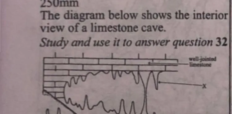
The diagram below shows the interior view of a limestone cave. The landform marked X is
A. stalagmiteB. grikeC. clintD. stalactiteCorrect Explanation The diagram shows formations hanging from the ceiling of the cave, which fits the definition of stalactites.
Gabbro is an example of
A. metamorphic rockB. igneous rockCorrect C. sedimentary rockD. fossilized rockExplanation Gabbro is a coarse-grained intrusive igneous rock formed from the slow cooling of magma beneath the Earth's surface.
The process by which strong winds lower the surface of deserts by lifting and blowing away of loose sand particles is known as
A. abrasionB. tractionC. attritionD. deflationCorrect Explanation Deflation is the process describing the removal of loose, fine particles by wind, which lowers desert surfaces and can form desert pavements.
The introduction of harmful substances into the environment is known as environmental
A. pollutionCorrect B. balanceC. interactionD. interventionExplanation The introduction of harmful substances into the environment is known as environmental pollution.
Which of the following is a function of urban settlements to rural settlements
A. unemploymentB. administrationCorrect C. food crop supplyD. trade deficitExplanation Urban centres house government offices and administrative institutions, providing governance and planning support to rural areas.
A major reason for low volume of trade among West African countries is
A. colonial tiesB. differences in climateC. similarity of productsCorrect D. political instabilityExplanation Many West African countries produce similar primary products (cocoa, crude oil, rubber, groundnut, etc.), and this similarity is considered the main factor hindering trade due to lack of distinct comparative advantages.
Which of the following classes of industry uses raw materials from agriculture, mining and fishing?
A. service industryB. primary industryC. secondary industryCorrect D. tertiary industryExplanation Secondary industry processes raw materials from agriculture, mining and fishing into finished or semi-finished goods.
One major reason for which air transportation is less patronized in Africa is due to the
A. limited number of airports in AfricaB. discomfort of travelling by airC. high airline operation taxesD. expensive nature of travelling by airCorrect Explanation High cost of tickets, maintenance, and poor income levels in many African countries make air travel unaffordable for most people.
One of the most effective ways of solving the problem of over-population in any country is by
A. educating couples on the need to give birth to fewer childrenCorrect B. advising its citizens to emigrate to other countries and return to their home country a year laterC. sensitizing its citizens to engage in agricultureD. discouraging rural-urban migrationExplanation Population control is best achieved through family planning education, empowering couples to manage birth rates.
Farmsteads, hamlets, villages and town are classification of settlements based on
A. functionB. locationC. sizeCorrect D. shapeExplanation This classification (farmstead, hamlet, village, town) is based on size and population density, from smallest to largest.
Which of the following pairs are reasons for establishing industries in urban centre? I. Employment II. Revenue generation III. Religious tolerance IV. Unemployment
A. I and II onlyCorrect B. II and IV onlyC. III and IV onlyD. I and IV onlyExplanation Industries create job opportunities (Employment) and help governments generate revenue through taxes and levies (Revenue generation), making I and II the valid reasons.
Which of the following types of goods is offered for sale at the global market by most developing countries
A. mining equipmentB. manufacturing goodsC. agricultural productsCorrect D. automobileExplanation Developing countries often export raw materials such as cocoa, cotton, coffee, and palm oil rather than manufactured or high-tech goods.
The term resort is usually associated with
A. tourismCorrect B. commerceC. bankingD. refugeeExplanation A resort is a place for relaxation, recreation or holidays, making it a core part of the tourism industry.
The membership of the Economic Community of West African States (ECOWAS) consists of
A. 12 countriesB. 13 countriesC. 15 countriesCorrect D. 16 countriesExplanation ECOWAS has 15 member countries: Benin, Burkina Faso, Cape Verde, Côte d'Ivoire, Gambia, Ghana, Guinea, Guinea-Bissau, Liberia, Mali, Niger, Nigeria, Senegal, Togo, and Sierra Leone.
Calculate the number of persons per square kilometers if a given country has a population of 100 million and a total land area of 500,000 km²
A. 20 persons per square kilometerB. 50 persons per square kilometerC. 200 persons per square kilometersCorrect D. 5,000 person per square kilometersExplanation Population density = Population ÷ Land area = 100,000,000 ÷ 500,000 = 200 persons per km².
Which of the following is not a primary factor to be considered in the siting of industries in Tropical Africa
A. existence of tertiary education institutionsCorrect B. nearness to marketC. nearness to source of raw materialsD. government policy on industrializationExplanation Primary siting factors for industries include access to raw materials, nearness to markets, and government policy, not the existence of tertiary education institutions.
Which of the following pairs are renewable source of energy
A. coal and nuclearB. natural gas and dieselC. hydro power and solarCorrect D. nuclear and natural gasExplanation Hydropower (from water) and solar (from the Sun) are common renewable energy sources that are naturally replenished.
Which of the following is not a characteristic of subsistence farming
A. the produce is mainly for home consumptionB. it is capital intensiveCorrect C. simple farm tools and method are usedD. it is labour intensiveExplanation Subsistence farming is typically labour-intensive and uses simple tools, focused on home consumption — it is not capital intensive.
An example of heavy industry is
A. printingB. food processingC. household goodsD. ship buildingCorrect Explanation Heavy industries involve large-scale production, heavy machinery and huge infrastructure, such as shipbuilding.
An example of heavy industry is
A. printingB. food processingC. household goodsD. ship buildingCorrect Explanation Heavy industries involve large-scale production, heavy machinery and huge infrastructure, such as shipbuilding.
Sign up free to unlock …and/or go further with premium services and No Ads .