All 50 questions from the West African Examinations Council (WAEC) Geography 2023 Objective paper, with the correct answer and a full explanation for each. Free, no signup needed.
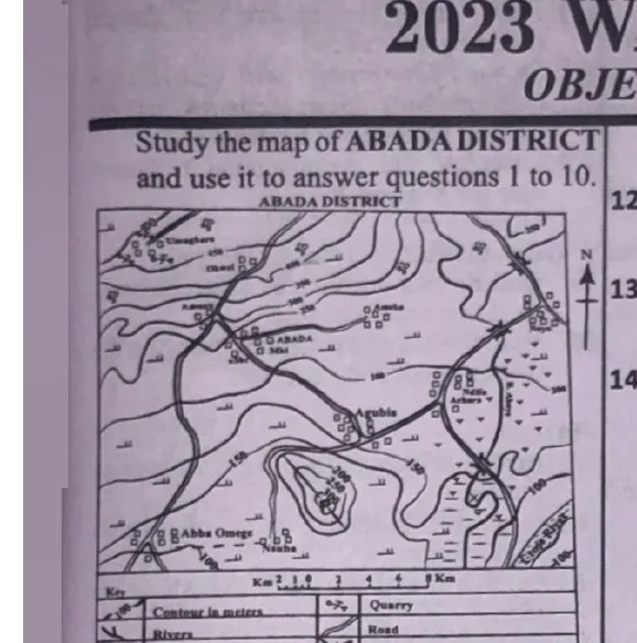
Which of the following towns is not intervisible from Agubia?
A. Ameka
B. ABADA
C. Ndifu Achara
D. NsubaCorrect
Explanation
Generally, if there is an obstacle (e.g. mountains/ridge) which can obstruct the line of sight between two locations, the locations will not be intervisible. The ridge obstructs the view between Agubia and Nsuba.
The feature marked P in the mapped area can best be described as a
A. mountain
B. knoll
C. valley
D. ridgeCorrect
Explanation
The structure labelled 'P' is a ridge. A ridge is a strip of highland which is elongate and narrow, with contour lines running almost parallel to one another.
The distance between Umughara and Ndifu Achara as the crow flies is approximately
A. 8 km
B. 11 km
C. 18 kmCorrect
D. 23 km
Explanation
On the map, the distance between Umughara and Ndifu is approximately 9 cm; since 1 cm on the map represents 2 km on the land, the actual distance is (9×2) km = 18 km.
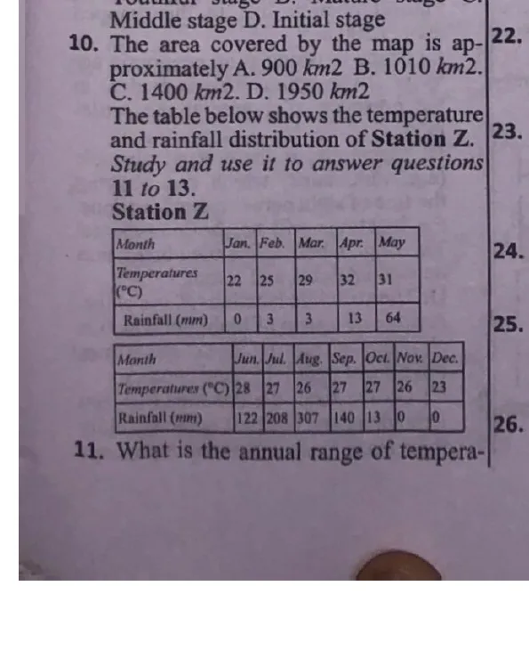
The wettest month of the year is simply the month with the highest amount of rainfall. The highest amount of rainfall is 307 mm and it is recorded in the month of August.
Which of the following represents the correct sequence in which denudation occurs?
A. Weathering → Erosion → DepositionCorrect
B. Deposition → Weathering→ Erosion
C. Erosion → Deposition → Weathering
D. Weathering → Deposition→ Erosion
Explanation
Breaking down of rock (weathering) will occur before it is swept away (erosion) and then deposition occurs. Thus, the sequence is: Weathering → Erosion → Deposition.
The part of the earth-crust covered by water bodies is known as the
A. sial
B. stratosphere
C. hydrosphereCorrect
D. atmosphere
Explanation
Hydrosphere is the liquid water component of the earth. It includes oceans, seas, lakes, ponds, streams and rivers, and covers about 70% of the earth's surface.
What is the temperature around an aeroplane flying at an altitude of 4000 metres if the temperature on the earth surface is 40 °C?
A. 12 °C
B. 14 °CCorrect
C. 26 °C
D. 66 °C
Explanation
For every 1000 m increase in height, the temperature drops by 6.5°C. Thus, at 4000 m: temperature fall = (6.5/1000)×4000 = 26°C. Since the temperature on the earth's surface is 40°C, the temperature at 4000 m = 40°C − 26°C = 14°C.
A. in the same direction as the prevailing windsCorrect
B. against the prevailing winds
C. at right angle to the prevailing wind
D. in a circular direction
Explanation
Barchan dunes display a crescentic shape with crest aligned perpendicular to the prevailing wind and horns directed parallel to it, and they move in the same direction as the prevailing winds.
Town C is located on latitude 15°E while Town D is located on latitude 60°E. If the local time in Town C is 7.00 a.m., what will be local time in Town D?
A. 4.00 p.m.
B. 4.00 a.m.
C. 10.00 p.m.
D. 10.00 a.m.Correct
Explanation
Difference in longitude = 60°−15° = 45°. 15° = 1 hr, so 45° = (1/15)×45 = 3 hrs. Since D is east of C, time is gained at D; thus, if the time in Town C is 7 am, the time in Town D = 7 am + 3 hrs = 10 am.
Under the Greek system of climate classification, the world is divided into
A. hot, temperate and dry zones
B. torrid, equatorial and tropical zones
C. temperate, frigid and hot zones
D. torrid, temperate and frigid zonesCorrect
Explanation
The ancient Greeks were among those that first attempted climate classification. Under the Greek system, the world is divided into three zones: torrid, frigid and temperate.
An isotherm is a line drawn on a map joining places of equal
A. cloud cover
B. pressure
C. rainfall
D. temperatureCorrect
Explanation
An isotherm is a line drawn on a map to join places of equal temperature. (Isobars join places of equal atmospheric pressure; isohyet joins places with equal rainfall; isoneph joins places of equal cloudiness.)
Plantation crops are those crops grown on a large scale in a contiguous region and are owned and managed by an individual or a company. Examples are coffee, rubber, oil palm, coconut and cocoa. Rye is not a typical plantation crop.
The sparse population in the middle belt of West Africa can be traced to all the following except
A. inter-ethnic war
B. Arab slave trade in the north
C. tsetse fly infestation
D. concentration of industriesCorrect
Explanation
Sparse population simply means an area that contains few people. There is no way concentration of industries will be a reason for sparse population — rather it attracts population.
The most common form of migration experienced in countries of Tropical Africa is
A. urban-urban migration
B. rural-rural migration
C. urban-rural migration
D. rural-urban migrationCorrect
Explanation
Rural-urban migration is the most common form of migration experienced in countries of tropical Africa. A key reason for this is the search for better economic opportunities.
Great Britain and Germany are trading partners of West African countries from
A. Western EuropeCorrect
B. North America
C. South America
D. The Far East
Explanation
Great Britain is located off the northwestern coast of mainland Europe. Germany is located in Central Europe but its western regions are commonly categorized as part of Western Europe.