Geography 2022 Theory — Question 1
PAPER 2, Q1(a) List four modes of transportation.
Model answer
Road transportation, Rail transportation, Water transportation, Air transportation (Pipeline transportation is also a valid 5th mode).
All 26 questions from the West African Examinations Council (WAEC) Geography 2022 Theory paper, with the correct answer and a full explanation for each. Free, no signup needed.
Advertisement
PAPER 2, Q1(a) List four modes of transportation.
Model answer
Road transportation, Rail transportation, Water transportation, Air transportation (Pipeline transportation is also a valid 5th mode).
PAPER 2, Q1(b) Outline five reasons for the construction of railways in developing countries.
Model answer
To supply raw materials to other parts of the country (e.g. East African railway); to link important cities and facilitate movement of people (e.g. Abidjan–Ouagadougou); to link different regions and promote inter-regional trade (e.g. North and South of Nigeria); to open up new areas for major crop production (e.g. Jos–Maiduguri); to tap agricultural, mineral and forest resources; for administration and postal services.
PAPER 2, Q1(c) Highlight three measures that can be taken to improve rail transportation in developing countries.
Model answer
Deliberate effort to expand the rail network to generate economic growth; government should make capital available to railway authorities, with training/re-training of personnel; adoption of standard gauges, faster engines and coaches, double tracks, and improved communication systems for operational efficiency.
PAPER 2, Q2(a) Distinguish between urbanisation and population density.
Model answer
Urbanisation means a change in the functions of a settlement from a rural to an urban character. Population density is the number of persons per unit area of land. An urbanized town may not necessarily be overpopulated.
PAPER 2, Q2(b) Highlight four problems created by urbanisation in Tropical Africa.
Model answer
Increased demand for goods and services (from high influx of people); inadequacy of social amenities such as pipe-borne water and electricity; increase in social vices such as robbery and car snatching; inadequacy of land, leading to land fragmentation and reduced farmland/yields.
PAPER 2, Q2(c) In what ways can the problems highlighted in 2(b) be solved?
Model answer
Introduce price control measures to cushion the effect of high demand; improve provision of social amenities; improve security; government should provide modern farming techniques while developing new towns.
PAPER 2, Q3(a) State four characteristics of local craft industries.
Model answer
A small labour force mainly made up of family members; small quantities of articles produced; less capital intensive; irregular hours of work; prices of products are negotiable, using simple tools.
PAPER 2, Q3(b) Identify three limitations of local craft industries.
Model answer
Affected by lack of raw materials, which hinders production; poor patronage from indigenes due to poor finishing and low purchasing power; lack of modern equipment, relying on physical human labour which limits production; problem of transporting finished products from the interior to urban markets; irregular income.
PAPER 2, Q3(c) Explain five factors that have contributed to the high volume of trade between developed and Tropical African countries.
Model answer
High level of technology in developed countries increases trade volume; high level of savings in developed countries makes production cheaper and export easier; colonial ties incline some developing countries toward trade with former colonial masters; differences in import duties between countries; differences in prices of goods (foreign goods often cheaper than local ones); preference for imported goods by countries like Nigeria.
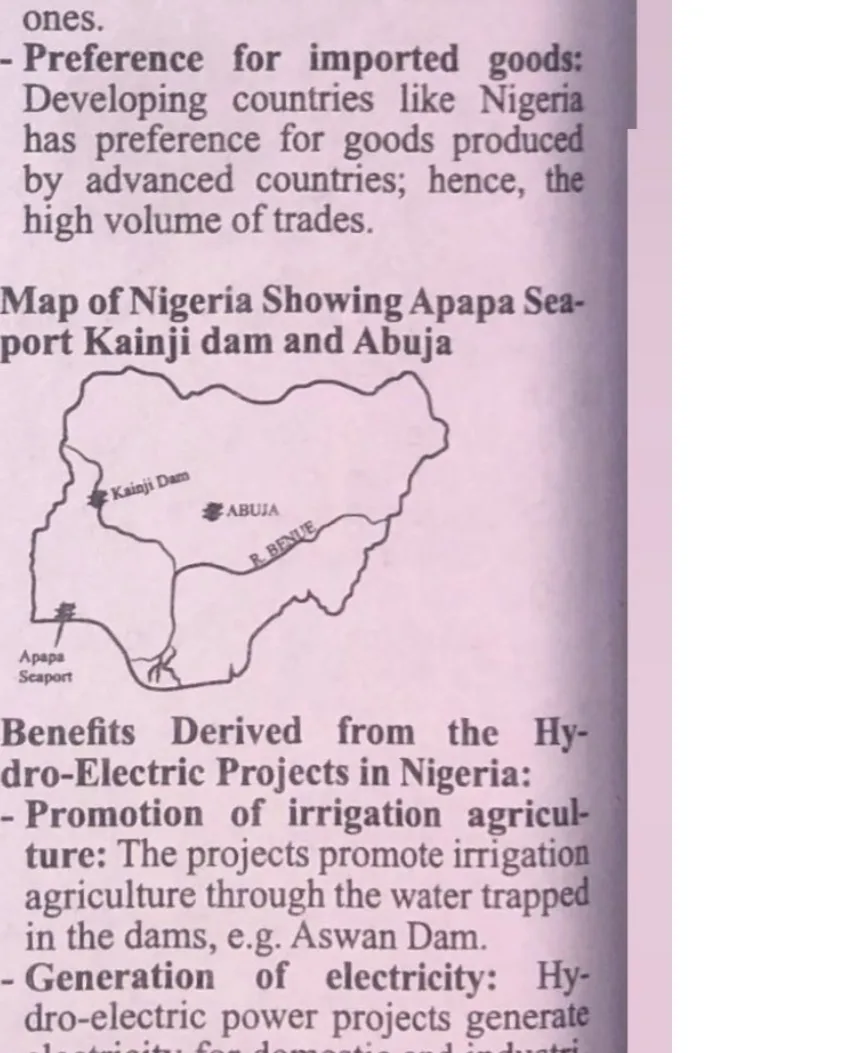
PAPER 2, Q4(a) Draw a sketch map of Nigeria. On the map, locate and name: (i) Apapa seaport; (ii) Kainji dam; (iii) Abuja.
Model answer
See sketch map in the Diagram column, showing Apapa Seaport on the southwest coast, Kainji Dam in the middle-west, and Abuja at the centre of the country.
PAPER 2, Q4(b) Highlight four benefits derived from the Hydro-Electric Power projects in Nigeria.
Model answer
Promotion of irrigation agriculture (water trapped in dams, e.g. used for irrigation); generation of electricity for domestic and industrial use (e.g. Kainji Dam); development of new towns around the projects; generation of revenue for government (including exporting electricity to neighbouring countries); tourist attraction; improvement in inland water transportation.
PAPER 2, Q4(c) Explain three advantages of seaports in Nigeria.
Model answer
Facilitation of international trade between Nigeria and other countries; free passage granted to all nations for smooth interaction; seaports serve as gateways for imports and exports; generation of revenue for government from import/export activities; employment generation; overall economic growth.
PAPER 2, Q5(a) List two crops that are cultivated under the bush fallowing system of farming in Nigeria.
Model answer
Root and tuber crops (e.g. yam, cassava); cereal crops (e.g. maize).
PAPER 2, Q5(b) Outline five characteristics of the bush fallowing system of farming in Nigeria.
Model answer
Very common in rural areas with abundant farmland; involves small holdings of farmland; food crops like yam, cassava and maize are grown; farmlands are left fallow after one or two years of cultivation, and farmers return after a fallow period of 2–5 years; uses the slash-and-burn method for land preparation; does not involve cultivation of cash crops like cocoa, rubber or oil palm; practiced where population density is very low, with little or no produce for sale.
PAPER 2, Q5(c) Highlight four disadvantages of the bush fallowing system of farming in Nigeria.
Model answer
Leads to wastage of land that could otherwise be used, by allowing it to lie fallow; leads to land fragmentation as population increases; does not allow for large-scale mechanized farming; results in poorer yields as population pressure shortens fallow periods, leading to soil erosion when the soil is exhausted; destroys valuable forest resources like timber.
PAPER 2, Q6(a) Draw a sketch map of Nigeria. On the map, locate and name: (i) Jos plateau; (ii) one river that flows into the Atlantic Ocean; (iii) one natural lake; (iv) Port Harcourt.
Model answer
See sketch map in the Diagram column, showing the Jos Plateau (north central), a river flowing into the Atlantic Ocean (e.g. River Niger), a natural lake (e.g. Lake Chad), and Port Harcourt in the south.
PAPER 2, Q6(b) Identify three problems of development in Lagos State.
Model answer
Inadequate job opportunities relative to the population of urban dwellers; overcrowding; inadequate physical and social infrastructure; water pollution from indiscriminate disposal of sewage, waste and effluents.
PAPER 2, Q6(c) Suggest three solutions to the problems identified in 6(b).
Model answer
Government should create adequate job opportunities; promulgate and enforce environmental laws to check indiscriminate waste disposal; provide affordable housing; provide adequate physical and social infrastructural facilities.
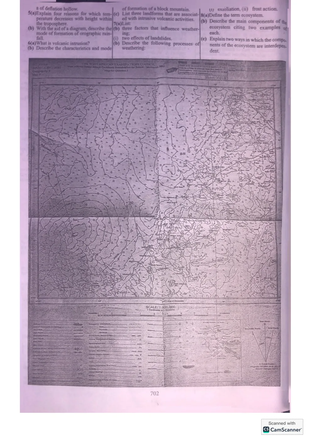
PAPER 3, Q1. Study the map extract provided on a scale of 1:100,000. (a) On the map extract, mark and name: (i) the 1460 Primary Trigonometrical Station (PTS); (ii) col (CL); (iii) gentle slope (GS); (iv) an area that rises above 1900 feet in the north (ARS); (v) a confluence in the northwest (CF). (b) Calculate the gradient along the line A to B (use the metric method of measurement). (c) Using evidence from the map, outline three reasons for which FUTUK is likely to be a more important settlement than Lungo.
Model answer
(a) See the map extract in the Diagram column — the five features should be marked directly at their respective locations on the map. (b) Gradient G = Δy/Δx = (y2−y1)/(x2−x1) = (11.7−0.0)/(2.9−0.0) ≈ 4.0 (using the metric method). (c) FUTUK is likely more important than Lungo because: it is the commercial centre of the mapped area (presence of a market); it is the educational centre (presence of a school); it is a fishing area, due to the presence of many rivers and a confluence nearby.
PAPER 3, Q2. Table F shows the number of students who gained admission into three Nursing Training Schools (A, B, C) from 2001 to 2003 (A: 40,60,50; B: 50,40,40; C: 60,30,40). (a) Represent the data with a compound bar graph, using the years as the base (x-axis) and a scale of 2cm to 20 students on the y-axis. (b) Calculate: (i) the number of students admitted into School A for the entire period; (ii) the number of students admitted into all three schools in 2003; (iii) the difference in enrolment between Schools A and C for the entire period. (c) Outline one major difference between a simple bar chart and a compound bar chart.
Model answer
(a) See the compound bar graph in the Diagram column. (b)(i) School A total = 40+60+50 = 150 students. (ii) Total for 2003 = 50(A)+40(B)+40(C) = 130 students. (iii) School A total=150; School C total=60+30+40=130. Difference = 150−130 = 20 students. (c) A simple bar chart consists of one unit/variable, while a compound bar chart consists of two or more units/variables combined in each bar.
PAPER 3, Q3(a) List two examples of volcanic mountains in the world. (b) With the aid of an annotated diagram, describe how composite cones are formed. (c) Outline three causes of landslides.
Model answer
(a) Mount Kilimanjaro (Tanzania); Fujiyama/Mount Fuji (Japan). (b) See annotated diagram in the Diagram column. A composite cone (stratovolcano) is built up of alternating layers of ash and lava: lava pours out and forms a layer on top of the ash, and this process repeats with each eruption. When the volcano explodes, its top is blown apart and disintegrates into rocks, bombs and ash, which then settle to build further layers, giving the cone its characteristic broad base and steep convex slopes. (c) Human activity on steep slopes (farming, mining, construction); earthquakes or volcanism; a steep slope being undercut by a river; heavy rainfall/deformation of slopes.
PAPER 3, Q4(a) Name three processes of wind transportation in an arid region. (b) With the aid of a diagram, describe the characteristics and mode of formation of a deflation hollow.
Model answer
(a) Deflation, Abrasion, Attrition. (b) See diagram in the Diagram column. Characteristics: formed by wind deflation; a desert landform of varying depths; a basin with a saucer shape; can be very extensive, forming oases in deserts. Mode of formation: wind exerts frictional force on loose rock particles, lifting and scooping away loose material; this lowers the land surface over time; wind eddies help deepen and enlarge the hollow, especially in soft rock zones, forming a depression (deflation hollow) that may reach the water table and produce oases or swamps (e.g. Fayum and Dakhla in Egypt, and areas of Wyoming, USA).
PAPER 3, Q5(a) Explain four reasons for which temperature decreases with height within the troposphere. (b) With the aid of a diagram, describe the mode of formation of orographic rainfall.
Model answer
(a) The troposphere's gases absorb very little incoming solar radiation directly; air is instead heated by radiation/conduction from the earth's surface, so air closer to the surface is warmer; higher atmospheric pressure occurs near the surface due to gravitational pull, decreasing with altitude; high altitudes contain less dust and water vapour, allowing heat to escape and the air to remain cold. (b) See diagram in the Diagram column. Orographic rainfall occurs when moisture-laden air is forced to rise over a mountain barrier (usually on the windward slope). As the air rises, it expands and cools, relative humidity increases until the air becomes saturated, water vapour condenses into cloud, and rain falls on the windward slope, while descending (drier) air occurs on the leeward side.
PAPER 3, Q6(a) What is volcanic intrusion? (b)(i) Describe the characteristics of Block Mountains. (ii) Describe the mode of formation of a Block Mountain. (c) List three landforms that are associated with intrusive volcanic activities.
Model answer
(a) Volcanic intrusion is a body of intrusive igneous rock formed by the crystallisation of magma as it slowly cools below the earth's surface (forming features such as batholiths and dykes as it penetrates and solidifies within existing rock). (b)(i) Block mountains form suddenly (relative to fold mountains); they are lower in altitude than fold mountains; their summits are flat; they have steep slopes on all sides; they are often associated with an adjacent rift valley/graben; they are less widespread than fold mountains and are made up of sedimentary and metamorphic rocks. (ii) Block mountains form when two tectonic plates move apart, creating cracks/faults in the earth's crust; where parallel faults occur, the block of land between them may be uplifted, forming the block mountain (the raised block is called a horst). (c) Laccoliths, sills, dikes.
PAPER 3, Q7(a) List three factors that influence weathering. (b)(i) State two effects of landslides. (ii) Describe the processes of weathering: exfoliation and frost action.
Model answer
(a) Climate, types of rocks, relief. (b)(i) Loss of life and infrastructure; damage to land and loss of natural resources. (ii) Exfoliation is the peeling off of rock surfaces due to alternate expansion (by day, as outer layers of heated rock expand faster than the cooler interior) and contraction (by night, as the outer layer cools more rapidly). Frost action occurs in polar/temperate regions where water collects in cracks or joints of rocks on high mountains; this water freezes at night or in winter, and the resulting expansion causes the rock to crack.
PAPER 3, Q8(a) Define the term ecosystem. (b) Describe the main components of the ecosystem, citing two examples of each. (c) Explain two ways in which the components of the ecosystem are interdependent.
Model answer
(a) An ecosystem is the community of plants and animals living together in harmony and interacting with their physical environment — i.e. the relationship between organisms and their physical environment. (b) Abiotic component: the non-living part of an ecosystem, including elements like soil and sunlight. Decomposers: micro-organisms (e.g. fungi and bacteria) that break down dead organic matter, releasing nutrients that producers need to make their food. (c) Water, carbon and nitrogen cycles provide energy and nutrients needed for plant growth; autotrophs (producers) depend on soil for physical support and nutrients, linking the biotic and abiotic components.
Advertisement
…and/or go further with premium services and No Ads.