All 38 questions from the West African Examinations Council (WAEC) Geography 2025 Theory paper, with the correct answer and a full explanation for each. Free, no signup needed.
Paper 2, Section A 1(a): Highlight five characteristics of urban settlements in developing countries.
Model answer
1. Rapid population growth from rural-urban migration.
2. Informal settlements/slums due to lack of affordable housing.
3. Inadequate infrastructure (limited clean water, sanitation, electricity, transportation).
4. High levels of unemployment and poverty despite city opportunities.
5. Significant social and economic inequalities in access to resources and services.
Paper 2, Section A 1(b): Explain five ways in which urban settlements depend on their surrounding rural settlements in developing countries.
Model answer
1. Food supply: rural areas are the primary producers of agricultural products.
2. Labour force: rural areas supply workers for urban industries and services.
3. Natural resources: urban areas depend on rural areas for water, timber and minerals.
4. Recreation and tourism: rural areas offer recreational/tourist opportunities for urban residents.
5. Connections: urban residents maintain cultural and social ties with rural communities.
Paper 2, Section A 2(b): Outline five factors that promote trade between Tropical Africa and the developed world.
Model answer
1. Demand for raw materials by developed countries.
2. Demand for manufactured goods/technology by Tropical Africa.
3. Foreign direct investment from developed countries.
4. Trade agreements that reduce trade barriers.
5. Improvements in transportation infrastructure (ports, roads).
Paper 2, Section A 2(c): Highlight four benefits of international trade to the economy of Tropical Africa.
Model answer
1. Increased economic growth through specialization/comparative advantage.
2. Access to new markets for Tropical African products.
3. Access to new technology and know-how.
4. Job creation in export-oriented industries.
Paper 2, Section A 3(a): What is pipeline transportation?
Model answer
A mode of transport that involves the movement of liquids, gases, or slurries (finely divided solids in liquid) over long distances through a system of interconnected pipes under pressure.
Paper 2, Section A 3(c): Outline four advantages of pipeline transportation in Tropical African countries, and four problems created by pipeline transportation in Tropical African countries.
Model answer
Advantages: (i) High efficiency for bulk liquids/gases. (ii) Lower operating costs than road/rail. (iii) Reduced road congestion and accidents. (iv) Reliable, all-weather, cost-effective transport with continuous supply.
Problems: (i) Vandalism and theft of pipelines. (ii) High initial construction costs. (iii) Land acquisition challenges/conflicts with local communities. (iv) Maintenance/repair needs and vulnerability to sabotage or illegal tapping (bunkering), causing environmental damage and safety hazards.
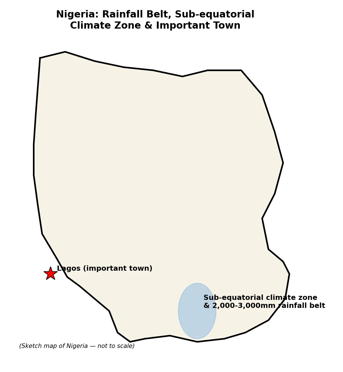
Paper 2, Section B 4(a): Draw an outline map of Nigeria. On the map, show and name: (i) one area that receives an annual rainfall of 2,000mm-3,000mm; (ii) one area noted for the Sub-equatorial climate; (iii) one important town in 4(a)ii.
Model answer
Outline map of Nigeria to show: (i) the southern coastal belt (e.g. Niger Delta area) as the zone receiving 2,000-3,000mm annual rainfall; (ii) Southern Nigeria (Sub-equatorial/Tropical Continental type region, e.g. around Lagos-Calabar belt) as the Sub-equatorial climate area; (iii) Lagos (or Port Harcourt/Calabar) marked as an important town in that area. [Diagram: outline map of Nigeria with rainfall belt, climate zone and town marked]
Paper 2, Section B 4(b): Identify four factors that affect the distribution of rainfall in Nigeria.
Model answer
1. Latitude/distance from the Equator — rainfall decreases northwards.
2. Movement of the Inter-Tropical Discontinuity (ITD) — seasonal migration controls the rainy season.
3. Distance from the coast/continentality — coastal areas get more rainfall from Atlantic moisture.
4. Altitude and relief — higher elevations generally receive more rainfall; prevailing winds also influence rainfall patterns.
Paper 2, Section B 4(c): Outline three characteristics of the Sub-equatorial climate in Nigeria.
Model answer
1. High temperatures year-round with minimal annual variation (25-28°C average).
2. High total annual rainfall, usually 1,500mm-3,000mm or more.
3. Distinct double maxima rainfall pattern — two wet seasons (with a short 'August break') and two dry seasons, one short and one longer influenced by the Harmattan.
Paper 2, Section B 5(a): Outline five factors that promote the cultivation of cocoa in Nigeria.
Model answer
1. Fertile, well-drained soil.
2. Favourable climate (rainfall 1,200-2,000mm annually; temperatures 25°C-28°C).
3. Rich, loamy soils found in areas like Ondo, Osun and Cross River states.
4. Shade from forest cover for young cocoa plants.
5. Availability of labour for planting, weeding and harvesting; access to markets and roads (e.g. Port Harcourt) also helps.
Paper 2, Section B 5(b): Identify five solutions to the problems that limit the cultivation of cocoa in Nigeria.
Model answer
1. Effective pest and disease control/management.
2. Improved/modern farming techniques (pruning, fertilization).
3. Access to credit and financial assistance for farmers.
4. Infrastructure development to move cocoa to markets.
5. Research and development of high-yielding, disease-resistant varieties; sustainable practices and rehabilitation/replanting programmes.
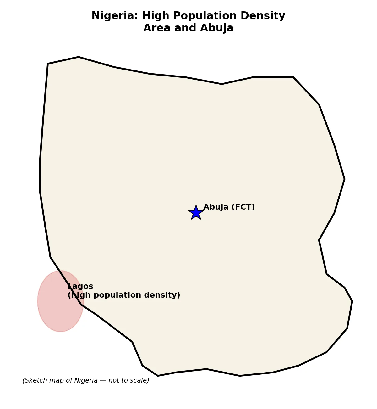
Paper 2, Section B 6(a): Draw an outline map of Nigeria showing: (i) one area noted for high population density; (ii) Abuja.
Model answer
Outline map of Nigeria marking Lagos (area of high population density) and Abuja (the Federal Capital Territory). [Diagram: outline map of Nigeria with Lagos and Abuja marked]
Paper 2, Section B 6(b): Outline five reasons that have accounted for the high population density in the area identified in 6(a)(i) (Lagos).
Model answer
1. It is a major administrative/commercial headquarters.
2. Great employment opportunities that swell the population.
3. Presence of industries providing jobs.
4. Presence of markets and business/trading activities.
5. Presence of infrastructure such as railways, an airport and a seaport, attracting migrants.
Paper 2, Section B 6(c): Country Z has a population of 140,000,000 and a total land area of 350,000 km². Calculate the population density of Country Z.
Model answer
Population density = Total population ÷ Total land area = 140,000,000 ÷ 350,000 = 400 persons per km².
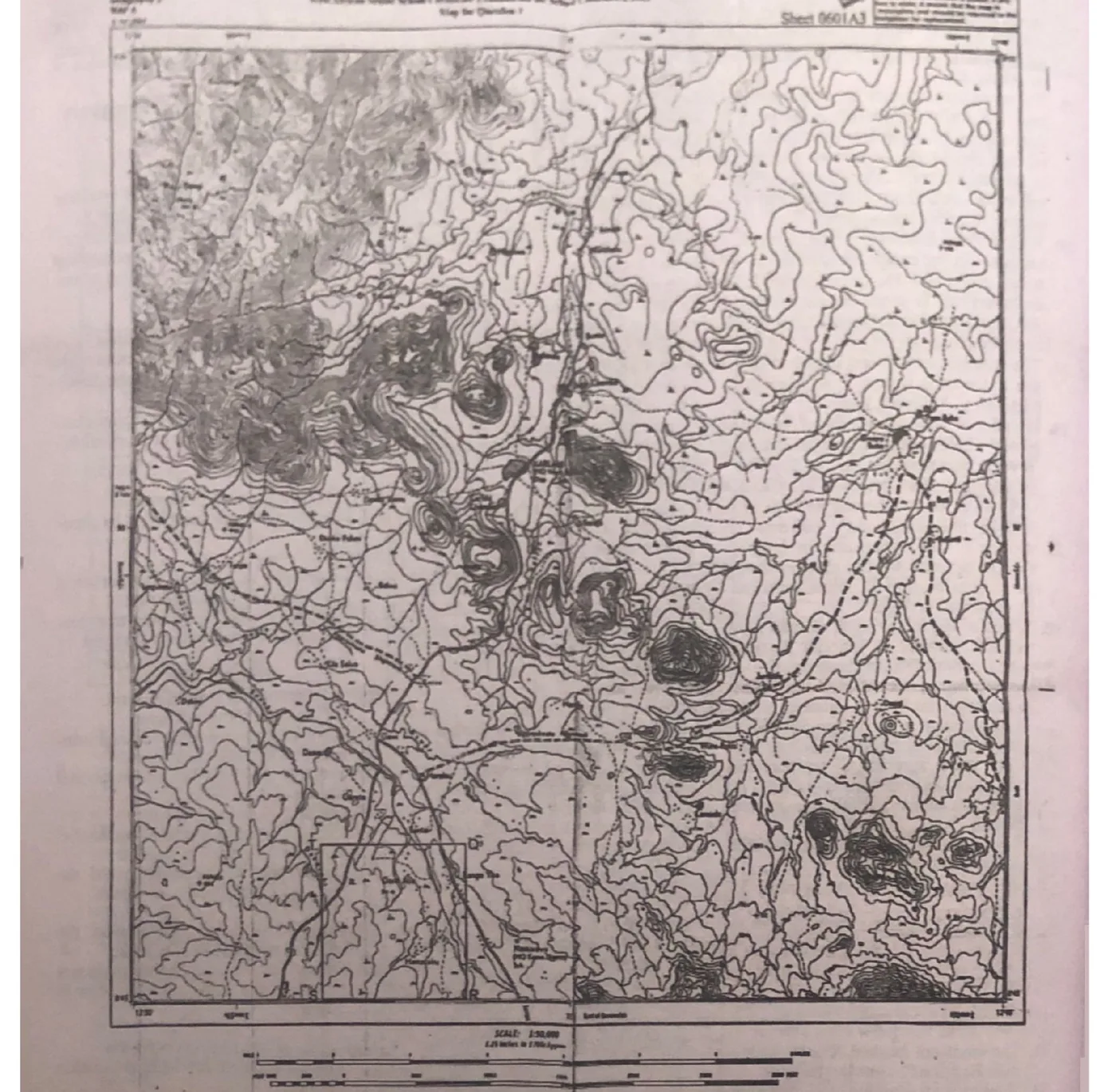
Paper 3, 1(a): Study the map extract provided on a scale of 1:50,000. In your answer booklet, draw a new outline of the section labelled QRST to a scale of 1:25,000.
Model answer
New outline length = original length × (50,000/25,000) = original length × 2. If QRST measures about 6 cm (±0.2 cm) on the original (i.e. 5.8-6.2 cm), the new outline should measure about 12 cm (11.6-12.4 cm).
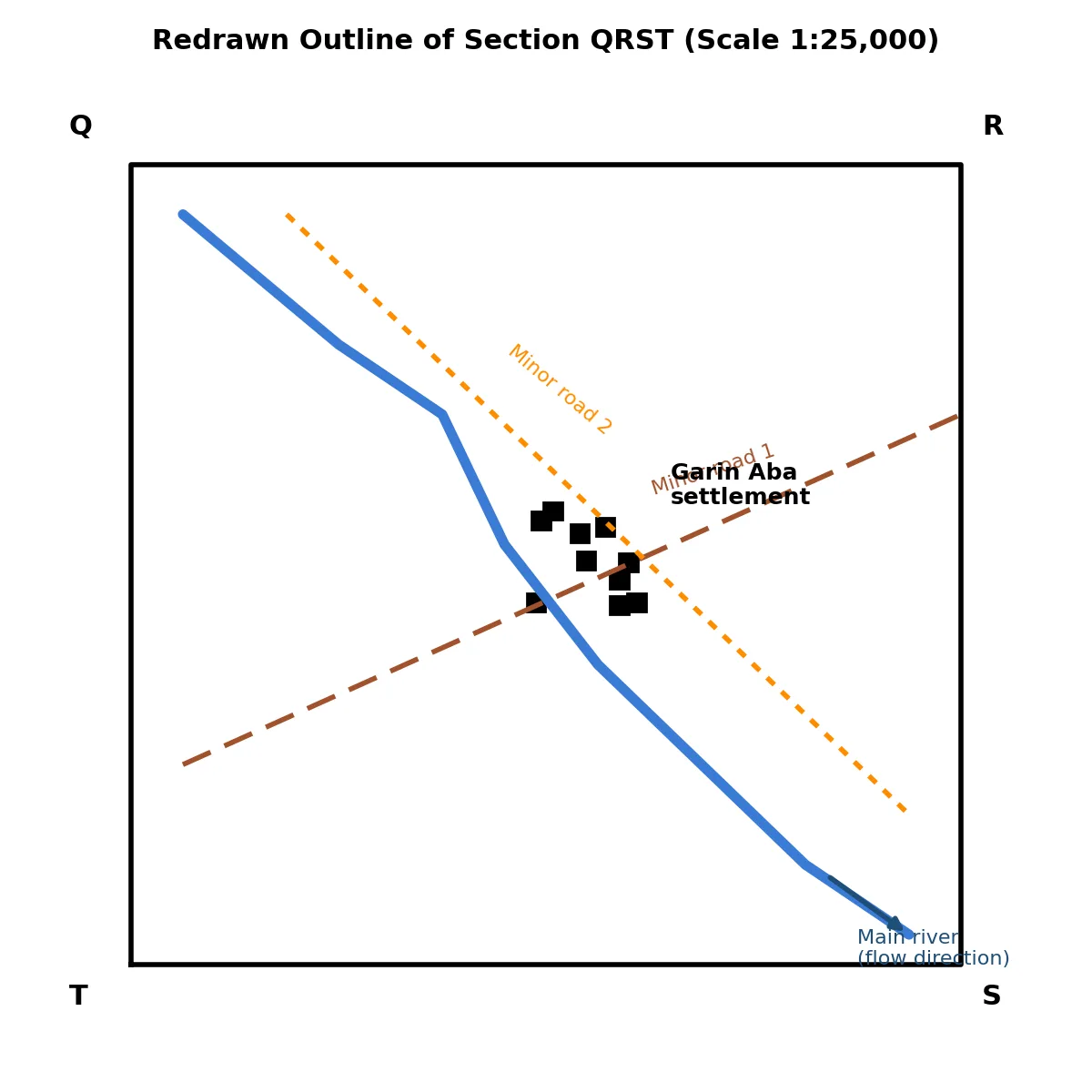
Paper 3, 1(b): In your outline, insert and name: (i) the two minor roads; (ii) the main river and indicate its direction of flow with an arrow; (iii) Garin Aba settlement.
Model answer
Insert and label the two minor roads, draw the main river with an arrow showing its direction of flow, and mark and name the Garin Aba settlement on the new outline. [Diagram: redrawn QRST outline with minor roads, river with flow-direction arrow, and Garin Aba settlement labelled]
Paper 3, 1(c): Outline three reasons for which KAR-LAHI is the most important settlement in the mapped area.
Model answer
1. Its accessibility due to the presence of a minor road and minor paths.
2. It is the largest, built-up settlement in the mapped area.
3. It performs administrative and judicial functions (it is the headquarters of Verre district and has a court house), giving it more functions than any other settlement.
Paper 3, 1(d): Using evidence from the map, identify three economic activities of the inhabitants in the mapped area.
Model answer
1. Farming — evidenced by the presence of scattered cultivation.
2. Health care services — evidenced by the presence of a dispensary.
3. Hunting — evidenced by the presence of forest and savanna; (transportation and educational services are also supported by roads/paths/rivers and schools).
Paper 3, 2(a): Table C shows the value of imported commodities (in million Naira) for a country from 2016-2020: 2016=80, 2017=120, 2018=240, 2019=60, 2020=300. Using a vertical scale of 2cm to represent 40 million units, construct a divergent bar graph to represent the data.
Model answer
Total value = 80+120+240+60+300 = 800 million Naira. Mean = 800 ÷ 5 = 160 million Naira.
Deviations from the mean: 2016 = 80-160 = -80m; 2017 = 120-160 = -40m; 2018 = 240-160 = +80m; 2019 = 60-160 = -100m; 2020 = 300-160 = +140m.
Plot a divergent bar graph with the mean (160m) as the baseline, bars extending above the line for positive deviations (2018, 2020) and below for negative deviations (2016, 2017, 2019), using the scale 2cm = 40 million units.
Paper 3, 2(b): State two disadvantages of divergent bar graphs.
Model answer
1. Difficulty in comparison since the bars start from different baselines.
2. The use of multiple colours/bars can create visual clutter, take up more space, and be difficult to read or interpret.
Paper 3, 3(b): State three characteristics of the lithosphere.
Model answer
1. Also called the Earth's crust; it is the solid portion of the earth.
2. It is the outermost layer or zone of the earth and forms the landmass.
3. It varies in thickness from about 10 km to 50 km.
Paper 3, 3(c): Outline five benefits of the lithosphere.
Model answer
1. Supports human life and agricultural purposes.
2. Forms the basis of all human settlements.
3. Source of minerals.
4. Aids transportation through the construction of roads.
5. Holds plants, is a source of springs and rivers, and its scenic beauty promotes tourism.
An artesian well is a well that taps into a confined underground aquifer, where water is under pressure and rises to the surface naturally, without pumping.
Paper 3, 4(b): Highlight four conditions that favour the formation of an artesian well.
Model answer
1. Presence of a down-warped or syncline basin/depression.
2. A layer of permeable rock (aquifer) lying between two layers of impermeable rock.
3. One or both ends of the permeable layer exposed at the surface to allow water to enter.
4. Sufficient rainfall at the exposed end, with water saturated in the permeable layer to build up hydrostatic pressure.
Paper 3, 5(a): State one difference between weather and climate.
Model answer
Weather is the atmospheric condition of a place at a given/short period of time, while climate is the average weather condition of a place studied over a long period, usually 30 years or more.
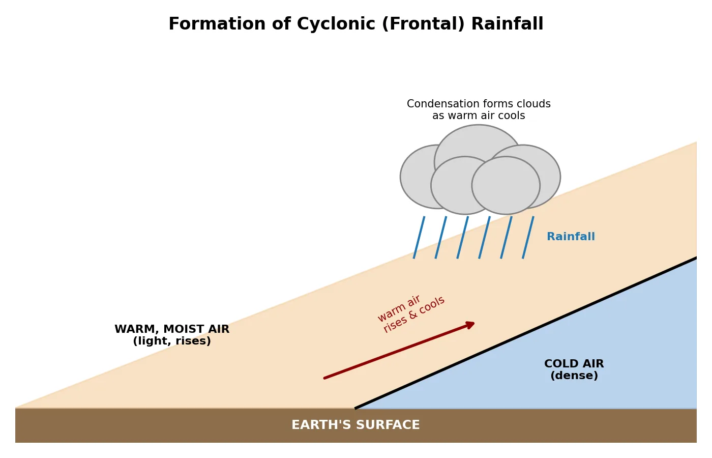
Paper 3, 5(b): With the aid of a diagram, describe the mode of formation of cyclonic (frontal) rainfall.
Model answer
Cyclonic rainfall occurs in the tropics and temperate regions when two air masses of different characteristics meet and their turbulence creates rainfall. The warm, lighter, moisture-laden air rises over the cold, denser air; as it rises it expands and cools; at the dew/saturation point clouds form as the vapour condenses; the water droplets coalesce and become too heavy to remain suspended, and fall as cyclonic/frontal rainfall. [Diagram: cross-section showing warm air rising over cold air at the meeting point, with condensation and rainfall forming]
Paper 3, 5(c): Highlight three benefits of cyclonic rainfall.
Model answer
1. Helps in the modification of climate.
2. Relieves drought and replenishes water sources.
3. Maintains ecosystem balance and reduces the risk of wildfires.
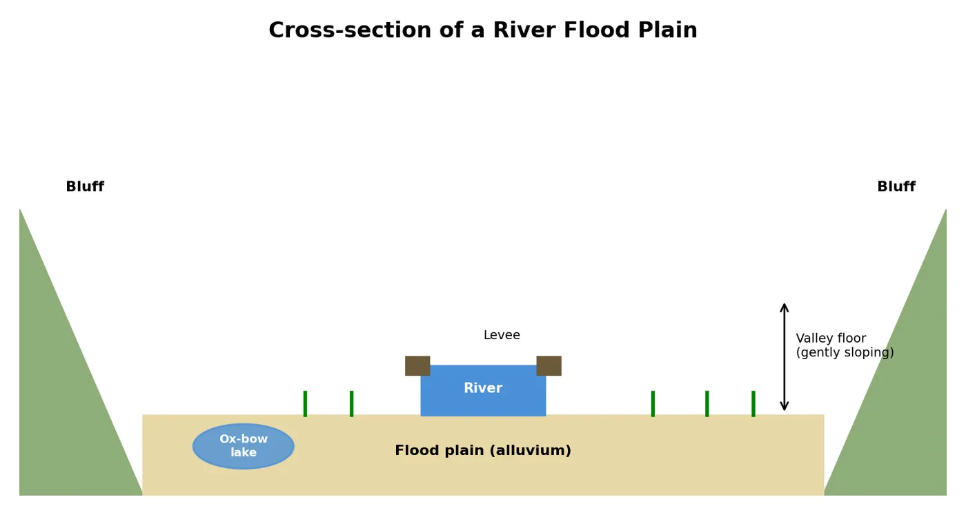
Paper 3, 6(b): With the aid of a diagram, describe the characteristics and mode of formation of a flood plain.
Model answer
A flood plain is found in the lower course of a river, on both sides/banks, and is a feature of river deposition. It forms an extensive, gently sloping land covered by alluvium, with a flat valley floor bounded by a bluff. It is usually low-lying, flat and broad, becomes flooded when the river overflows its banks, and is often poorly drained with features such as deltas, ox-bow lakes, levees and meanders, and supports vegetation. [Diagram: cross-section of a river flood plain showing raised river banks/levees, ox-bow lake, and alluvium deposits]
Paper 3, 7(b): Highlight three similarities between a zeugen and a yardang, and two differences between a zeugen and a yardang.
Model answer
Similarities: (i) Both are found in hot desert regions. (ii) Both are wind-erosional features found in areas of active mechanical weathering. (iii) Both have elongated ridges with rocks of varying resistance to erosion, typically 10-30 metres long.
Differences: (i) In a zeugen, rocks are arranged in horizontal layers, while in a yardang, rocks are arranged in vertical layers. (ii) A zeugen has an elongated ridge with steep slopes and a flat top and is separated from others by a deep furrow, while a yardang has low, overhanging ridges with steep sides and is separated from others by a long, narrow furrow.
Paper 3, 8(b): Highlight four ways by which mankind destroys the natural environment.
Model answer
1. Deforestation.
2. Burning of fossil fuels/release of carbon dioxide, and pollution.
3. Overfishing and overgrazing.
4. Improper disposal of waste, mining/quarrying and urbanization.
Paper 3, 8(c): Outline two measures that can be adopted to control the destruction of the natural environment.
Model answer
1. Public education on environmental preservation and legislation/enforcement of environmental laws.
2. Use of environmentally friendly energy sources, proper treatment/disposal of waste, and banning the use of items that produce chlorofluorocarbons.
Advertisement
Sign up free to unlock
Score tracking
Practice history
Saved questions
Progress dashboard
Personalized sessions
Weak-topic breakdown
…and/or go further with premium services and No Ads.